|
search place name
|
||
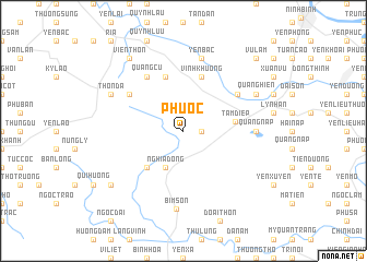
Phú Ốc (Vietnam)Phú Ốc is a town in Vietnam. An overview map of the region around Phú Ốc is displayed below.
regional and 3d topo map of Phú Ốc, Vietnam ::
Phú Ốc airports ::
The nearest airport is HAN - Hanoi Noibai Intl, located 118.8 km north of Phú Ốc.
Nearby towns ::
Quang Suối (1.7km east) //
Nghĩa Ðộng (4.1km south west) //
Dũng Lươc (5.1km south west) //
Tam Ðiệp (5.0km east) //
Vĩnh Khương (5.8km north) //
Lạc Thành (5.8km north) //
Làng Ca (6.4km north east) //
Phú Hữu (6.4km north west) //
Quảng Cư (6.6km north west) //
Quảng Nap (7.0km east) //
Yên Bạc (7.6km north) //
Nguyễn Thôn (7.6km north) //
Bỉm Sơn (8.0km south) //
Quang Hiển (7.9km north east) //
Thôn Ðâ (7.9km north west) //
Gia Miên Nội (8.9km south west) //
Viện Thôn (9.1km north west) //
Vũ Lâm (10.2km north east) //
[all distances 'as the bird flies' and approximate]  Places with similar names to Phú Ốc, Vietnam ::
Disclaimer :: Information on this page comes without warranty of any kind |
||
|
Where is Phú Ốc? Elevation and coordinates ::
Latitude (lat): 20°9'0"N Longitude (lon): 105°52'0"E
Elevation (approx.): 53m (map arrows pan, magnifying glasses zoom) |
||
|
Visiting Phú Ốc? Hotel/Accommodation ::
Book a hotel in Phú Ốc Travel Guide ::
Buy a travel guide for Vietnam rental cars ::
car rental offers GPS waypoint ::
download a GPX waypoint (PoI) of Phú Ốc for your GPS receiver
|
||