|
search place name
|
||
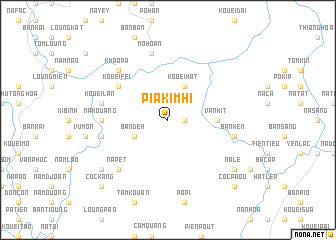
Pia Kim Hi (Bắc Thái, Vietnam)Pia Kim Hi is a town in the Bắc Thái region of Vietnam. An overview map of the region around Pia Kim Hi is displayed below.
regional and 3d topo map of Pia Kim Hi, Vietnam ::
Pia Kim Hi airports ::
The nearest airport is HAN - Hanoi Noibai Intl, located 118.1 km south of Pia Kim Hi.
Nearby towns ::
Bản Than (1.7km east) //
Bản Dem (3.9km south west) //
Kouei Hat (4.1km north east) //
Van Kit (5.1km east) //
Bản Siang (5.1km east) //
Lương Thượng (5.1km east) //
Pan Xa (5.1km east) //
Kouei Fei (6.3km north west) //
Na Kouang (6.9km west) //
Kouei Lan (7.1km west) //
Mô Hoan (7.6km north) //
Bản Dzian (7.6km north) //
Kouei Yin (7.6km north) //
Done Con (7.1km west) //
Tioc Vèn (7.1km west) //
Bản Ken (7.1km east) //
Na Pet (7.6km south west) //
Khao Pa (7.6km north west) //
Loung Xien (8.8km south west) //
Na Le (8.8km south east) //
Coc Kang (10.1km south west) //
Coc Paou (10.1km south east) //
[all distances 'as the bird flies' and approximate]  Places with similar names to Pia Kim Hi, Vietnam :: Disclaimer :: Information on this page comes without warranty of any kind |
||
|
Where is Pia Kim Hi? Elevation and coordinates ::
Latitude (lat): 22°16'0"N Longitude (lon): 106°2'0"E
Elevation (approx.): 520m (map arrows pan, magnifying glasses zoom) |
||
|
Visiting Pia Kim Hi? Hotel/Accommodation ::
Book a hotel in Pia Kim Hi Travel Guide ::
Buy a travel guide for Vietnam rental cars ::
car rental offers GPS waypoint ::
download a GPX waypoint (PoI) of Pia Kim Hi for your GPS receiver
|
||