|
search place name
|
||
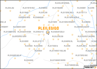
Plei Le Dido (Vietnam)Plei Le Dido is a town in Vietnam. An overview map of the region around Plei Le Dido is displayed below.
regional and 3d topo map of Plei Le Dido, Vietnam ::
Plei Le Dido airports ::
The nearest airport is NHA - Nhatrang, located 210.0 km south east of Plei Le Dido.
Nearby towns ::
Plei Dak (1.8km west) //
Plei Xôme (2.6km south west) //
Plei Lê Hatte (2.6km south east) //
Plei Deu Ngol (1) (3.6km east) //
Plei Neute (3.6km west) //
Plei Ngol Ho (3.7km north) //
Plei Deu Doath (4.1km south east) //
Plei Lê Ngo (1) (4.1km south east) //
Plei Torr (4.1km north east) //
Plei T”séo (2) (4.1km north west) //
Plei Lê Tôtt (5.2km south west) //
Plei T”séou (5.8km south) //
Plei Lang (2) (5.8km south) //
Plei Tott (5.8km south) //
Plei Torr Agne (6.6km north east) //
Plei Xôme (6.6km south west) //
Plei Ia Meur (6.6km north west) //
Plei Hơdrông Thoung (1) (7.4km north) //
Plei Kla (1) (7.6km north) //
Plei Tpang (7.8km south west) //
Plei Thaie Ya Glaé (8.2km south east) //
Plei Mê (1) (8.2km south west) //
Plei Ton (8.2km north east) //
Plei Ho Ngol (8.1km south east) //
Plei Néo (8.1km south west) //
Plei Yône Prompt (8.1km north east) //
Plei Néo (9.1km south west) //
Plei Hô (9.1km south east) //
Plei Ya Bo (9.2km north west) //
[all distances 'as the bird flies' and approximate]  Places with similar names to Plei Le Dido, Vietnam ::
// Palo Ladeado (PA)
// Plei Lê Tôtt (VN)
Disclaimer :: Information on this page comes without warranty of any kind |
||
|
Where is Plei Le Dido? Elevation and coordinates ::
Latitude (lat): 13°41'0"N Longitude (lon): 107°57'0"E
Elevation (approx.): 465m (map arrows pan, magnifying glasses zoom) |
||
|
Visiting Plei Le Dido? Hotel/Accommodation ::
Book a hotel in Plei Le Dido Travel Guide ::
Buy a travel guide for Vietnam rental cars ::
car rental offers GPS waypoint ::
download a GPX waypoint (PoI) of Plei Le Dido for your GPS receiver
|
||