|
search place name
|
||
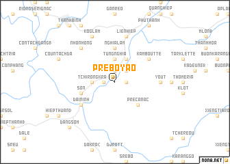
Pré Boyao (Lâm Ðồng, Vietnam)Pré Boyao is a town in the Lâm Ðồng region of Vietnam. An overview map of the region around Pré Boyao is displayed below.
regional and 3d topo map of Pré Boyao, Vietnam ::
Pré Boyao airports ::
The nearest airport is NHA - Nhatrang, located 108.2 km north east of Pré Boyao.
Other airports nearby include SGN - Ho Chi Minh City Tansonnhat Intl (210.3 km south west), Nearby towns ::
Pré Rion (1.8km east) //
Phú Hội (1) (1.9km north) //
Tchirong Tambor (1.8km west) //
Phú Hội (2) (2.6km north east) //
Tchirong Kra (3.6km west) //
Nam Sơn (1) (3.7km north) //
Tùng Nghĩa (3.7km north) //
Cao Bắc Lạng (4.1km north east) //
Nam Sơn (2) (4.1km north east) //
Pre Ca Nac (5.2km south east) //
Nghĩa Lâm (5.6km north) //
Son (5.8km west) //
Ðại Ninh (6.6km south west) //
Kamboutte (6.6km north east) //
Yout (7.3km east) //
Ðưc Trọng (7.6km north) //
Liên Hiệp (7.6km north) //
Nhơn Hông (7.8km north west) //
Koglam (8.3km north west) //
Dang Som (10.4km south west) //
[all distances 'as the bird flies' and approximate]  Places with similar names to Pré Boyao, Vietnam ::
Disclaimer :: Information on this page comes without warranty of any kind |
||
|
Where is Pré Boyao? Elevation and coordinates ::
Latitude (lat): 11°41'0"N Longitude (lon): 108°22'0"E
Elevation (approx.): 902m (map arrows pan, magnifying glasses zoom) |
||
|
Visiting Pré Boyao? Hotel/Accommodation ::
Book a hotel in Pré Boyao Travel Guide ::
Buy a travel guide for Vietnam rental cars ::
car rental offers GPS waypoint ::
download a GPX waypoint (PoI) of Pré Boyao for your GPS receiver
|
||