|
search place name
|
||
Qui Xa (Thanh Hóa, Vietnam)Qui Xa is a town in the Thanh Hóa region of Vietnam. An overview map of the region around Qui Xa is displayed below.
regional and 3d topo map of Qui Xa, Vietnam ::

Qui Xa airports ::
The nearest airport is HAN - Hanoi Noibai Intl, located 150.7 km north of Qui Xa.
Nearby towns ::
Mỹ Ðô (1.9km north) //
Trà Sơn Thượng (1.7km east) //
Hô Dàm (1.9km south) //
Kiện Trung (2.5km north east) //
Vĩnh Ðiên (2.5km north east) //
Lạc Ðô (2.5km north west) //
Nguyet Quang (2.5km north west) //
Phủ Lý (2.5km south east) //
Ðông Dương (3.7km north) //
Mật Thôn (3.7km north) //
Cẩm Tú (3.7km south) //
Thiệu Hóa (4.1km north west) //
Thạch Khê Tiền (4.1km south east) //
Trường Xuân (4.1km south east) //
Dông Chùy (4.1km south west) //
Ðồng Mỹ (5.1km north east) //
Vạn Lộc (5.6km south) //
Tòng Tân Nội (5.2km east) //
Ðắc Châu (5.2km east) //
Ngưỡng Ðưc (5.8km north) //
Ðại Lý (1) (5.5km east) //
Thiết Cương (5.5km west) //
Trạm Lô (5.5km west) //
Ngoc Tich (5.5km east) //
Ðại Bối (5.5km east) //
Phong Phú (1) (6.6km north east) //
Phú Lộc (6.6km north west) //
Ðồng Thành (7.4km south) //
Phù Chân (7.4km south) //
[all distances 'as the bird flies' and approximate] 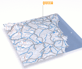 Places with similar names to Qui Xa, Vietnam ::
Disclaimer :: Information on this page comes without warranty of any kind |
||
|
Where is Qui Xa? Elevation and coordinates ::
Latitude (lat): 19°52'0"N Longitude (lon): 105°40'0"E
Elevation (approx.): 7m (map arrows pan, magnifying glasses zoom) |
||
|
Visiting Qui Xa? Hotel/Accommodation ::
Book a hotel in Qui Xa Travel Guide ::
Buy a travel guide for Vietnam rental cars ::
car rental offers GPS waypoint ::
download a GPX waypoint (PoI) of Qui Xa for your GPS receiver
|
||