|
search place name
|
||
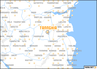
Tân Nghĩa (Thái Bình, Vietnam)Tân Nghĩa is a town in the Thái Bình region of Vietnam. An overview map of the region around Tân Nghĩa is displayed below.
regional and 3d topo map of Tân Nghĩa, Vietnam ::
Tân Nghĩa airports ::
The nearest airport is HAN - Hanoi Noibai Intl, located 110.4 km north west of Tân Nghĩa.
Nearby towns ::
Ðồng Kinh (1.9km north) //
Thần Huống (2) (2.5km north east) //
Trực Tầm (2.5km north west) //
Trà Lý (2.5km south east) //
Thiên Kiêu (2.5km south east) //
Chỉ Thiện (3.9km north east) //
Thần Ðầu (3.9km north east) //
Thượng Hòa (3.9km south west) //
Chiềm Thuận (4.1km north east) //
Lương Phú (4.1km south east) //
Ky Nhai (5.1km north west) //
Xuân Hòa Giáo (5.2km east) //
Vị Dương (5.6km north) //
Tiền Hải (5.6km south) //
Nghĩa Khê (5.6km south) //
Hải Linh (5.5km east) //
Phu Thành (5.5km east) //
Phật Lộc (6.6km north west) //
Lục Linh (6.4km north east) //
Thuyền Quan (6.4km north west) //
Ðại Hữu (6.6km south east) //
Kính Xuyên (2) (6.4km south east) //
Hạ Dồng (7.4km north) //
Khai Lai (7.6km north) //
Lũng Tả (7.2km east) //
Quân Hành (7.2km west) //
Lạc Thành (7.6km south) //
Ngoại Ðê (7.6km south) //
Trình Phố (7.6km south) //
[all distances 'as the bird flies' and approximate] 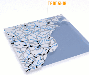 Places with similar names to Tân Nghĩa, Vietnam ::
Disclaimer :: Information on this page comes without warranty of any kind |
||
|
Where is Tân Nghĩa? Elevation and coordinates ::
Latitude (lat): 20°28'0"N Longitude (lon): 106°30'0"E
Elevation (approx.): 2m (map arrows pan, magnifying glasses zoom) |
||
|
Visiting Tân Nghĩa? Hotel/Accommodation ::
Book a hotel in Tân Nghĩa Travel Guide ::
Buy a travel guide for Vietnam rental cars ::
car rental offers GPS waypoint ::
download a GPX waypoint (PoI) of Tân Nghĩa for your GPS receiver
|
||