|
search place name
|
||
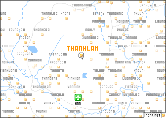
Thanh Lâm (Vĩnh Phú, Vietnam)Thanh Lâm is a town in the Vĩnh Phú region of Vietnam. An overview map of the region around Thanh Lâm is displayed below.
regional and 3d topo map of Thanh Lâm, Vietnam ::
Thanh Lâm airports ::
The nearest airport is HAN - Hanoi Noibai Intl, located 8.8 km south of Thanh Lâm.
Nearby towns ::
Ấp Xuan Hoa (1.7km east) //
Xuân Bảng (4.1km north east) //
Yệ Linh (5.1km south east) //
Phú Hữu (5.1km south west) //
Ấp Tân Long (5.2km west) //
Trung Gia (5.2km east) //
Ấn Nam Ly (5.6km north) //
Nam Lý (5.8km north) //
Ninh Liệt (5.5km east) //
Ấp Ðông Ðô (5.5km west) //
Ninh Môn (5.8km south) //
Hạ Gia (6.4km north east) //
Phú Môi (6.5km south east) //
Thanh Tri (6.4km south west) //
Ngoc Lâu (6.9km east) //
Xuân Bách (7.4km south) //
Tiên Dược Hạ (7.6km south) //
Lập Trí (7.2km west) //
Ninh Bắc (7.6km south) //
Yên Ninh (7.6km south) //
Sơn Long (7.6km south west) //
Phù Lôi (7.8km north east) //
Triều Lai (7.8km north east) //
Ða Hội (7.8km north east) //
Trại Dinh (7.8km south east) //
Vạn Phái (8.2km north east) //
Hiền Lương (7.8km south west) //
Ðau Tao (8.9km south east) //
Ðồng Cao (8.9km south east) //
[all distances 'as the bird flies' and approximate] 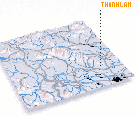 Places with similar names to Thanh Lâm, Vietnam ::
// Thenhlum (IN)
// Thanh Lâm (VN)
// Thanh Lâm (1) (VN)
// Thanh Lâm (4) (VN)
// Thanh Liêm (VN)
// Thanh Liêm (VN)
// Thânh Liêm (VN)
// Thịnh Lâm (VN)
Disclaimer :: Information on this page comes without warranty of any kind |
||
|
Where is Thanh Lâm? Elevation and coordinates ::
Latitude (lat): 21°18'0"N Longitude (lon): 105°49'0"E
Elevation (approx.): 36m (map arrows pan, magnifying glasses zoom) |
||
|
Visiting Thanh Lâm? Hotel/Accommodation ::
Book a hotel in Thanh Lâm Travel Guide ::
Buy a travel guide for Vietnam rental cars ::
car rental offers GPS waypoint ::
download a GPX waypoint (PoI) of Thanh Lâm for your GPS receiver
|
||