|
search place name
|
||
Thôn Tam Lang (Vietnam)Thôn Tam Lang is a town in Vietnam. An overview map of the region around Thôn Tam Lang is displayed below.
regional and 3d topo map of Thôn Tam Lang, Vietnam ::

Thôn Tam Lang airports ::
The nearest airport is DAD - Danang Intl, located 149.6 km south east of Thôn Tam Lang.
Other airports nearby include PKZ - Pakse (230.6 km south west), Nearby towns ::
Thôn An Mỹ (1.9km north) //
Thôn Mọc Ðức (1.9km south) //
An Binh (4.0km north east) //
Thôn Cam Vủ (4.0km north east) //
Thôn Nghĩa Hi (4.0km south west) //
Thiên Chánh (4.1km north west) //
Tho Xuân (4.1km north west) //
Xóm Tôt Bồng (5.1km north west) //
An Xuân (5.1km north east) //
Thôn Cam Lộ (5.3km west) //
Mỹ Hỏa (5.8km north) //
Trúc Sơn (5.8km north) //
Phi Thùa (6.5km north east) //
Thượng Nghĩa (6.5km north east) //
Cam Lộ (7.1km west) //
Xóm Rào Vịnh (7.4km south) //
Thôn Ba Thung (7.1km west) //
Vận Kim (7.6km north) //
Ðinh Tổ (7.3km east) //
Ðại Ðộ (7.3km east) //
Thôn Tân Ðịnh (7.3km west) //
Trúc Khê (7.7km north east) //
Phú Phương (8.2km north west) //
Nhà Thờ Bái Sơn (9.1km north west) //
Thôn Bảng Sơn (9.1km south west) //
Trúc Kinh (9.0km north east) //
Thôn Bái Án (9.0km north west) //
Kỳ Lâm (10.3km north east) //
Thôn An Hòa (10.3km north west) //
[all distances 'as the bird flies' and approximate] 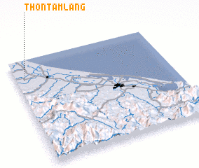 Places with similar names to Thôn Tam Lang, Vietnam :: Disclaimer :: Information on this page comes without warranty of any kind |
||
|
Where is Thôn Tam Lang? Elevation and coordinates ::
Latitude (lat): 16°49'0"N Longitude (lon): 107°3'0"E
Elevation (approx.): 7m (map arrows pan, magnifying glasses zoom) |
||
|
Visiting Thôn Tam Lang? Hotel/Accommodation ::
Book a hotel in Thôn Tam Lang Travel Guide ::
Buy a travel guide for Vietnam rental cars ::
car rental offers GPS waypoint ::
download a GPX waypoint (PoI) of Thôn Tam Lang for your GPS receiver
|
||