|
search place name
|
||
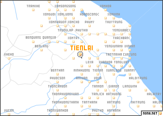
Tiên Lai (Vietnam)Tiên Lai is a town in Vietnam. An overview map of the region around Tiên Lai is displayed below.
regional and 3d topo map of Tiên Lai, Vietnam ::
Tiên Lai airports ::
The nearest airport is DAD - Danang Intl, located 165.9 km south east of Tiên Lai.
Other airports nearby include PKZ - Pakse (246.9 km south west), Nearby towns ::
Phan Xá (2) (1.8km east) //
Lâm Cao (1.9km north) //
Ðuy Viên (1.9km north) //
Ðặng Xá (1.9km north) //
Le Xa (1.9km south) //
Thủy Ba Hạ (1.8km west) //
Ðôn Duệ (1) (2.6km north east) //
Le Xa (2.6km south east) //
Liêm Công Tây (4) (3.5km east) //
Hiền Lương (3.5km east) //
Phúc Lâm (3.7km north) //
Minh Huong (3.7km south) //
Ðan Thẩm (4.0km north east) //
Liêm Công Tây (1) (4.0km north east) //
Hoang Xá (4.0km south east) //
Xóm Tây (4.1km north west) //
Thủy Ba Thượng (4.0km north west) //
Tien An (5.1km south east) //
Sa Lung (5.1km north west) //
An Xuân (5.6km south) //
Phú Thi (1) (5.6km north) //
Kinh Môn (5.8km south) //
Hồ Xá (5.8km north) //
Xuân Hòa (5.6km east) //
Võ Xá (6.6km south east) //
Hoàng Công (3) (6.6km north east) //
Liêm Công (1) (6.5km north east) //
Linh Hải (6.5km north west) //
Bến Than (6.5km south west) //
[all distances 'as the bird flies' and approximate]  Places with similar names to Tiên Lai, Vietnam ::
Disclaimer :: Information on this page comes without warranty of any kind |
||
|
Where is Tiên Lai? Elevation and coordinates ::
Latitude (lat): 17°1'0"N Longitude (lon): 107°1'0"E
Elevation (approx.): 5m (map arrows pan, magnifying glasses zoom) |
||
|
Visiting Tiên Lai? Hotel/Accommodation ::
Book a hotel in Tiên Lai Travel Guide ::
Buy a travel guide for Vietnam rental cars ::
car rental offers GPS waypoint ::
download a GPX waypoint (PoI) of Tiên Lai for your GPS receiver
|
||