|
search place name
|
||
Trai Ðồng Nông (Vietnam)Trai Ðồng Nông is a town in Vietnam. An overview map of the region around Trai Ðồng Nông is displayed below.
regional and 3d topo map of Trai Ðồng Nông, Vietnam ::

Trai Ðồng Nông airports ::
The nearest airport is SNO - Sakon Nakhon, located 261.1 km south west of Trai Ðồng Nông.
Nearby towns ::
Du Xương (3.5km east) //
Long Cơ (2) (4.0km south east) //
Nghĩa Môn (5.6km north) //
Mâc Táo (5.6km east) //
Yên Hâu (5.6km east) //
Xóm Sôi (5.6km east) //
Ðồng Xuân (5.6km east) //
Xóm Rừm (5.6km east) //
Trúc Hạ (5.8km south) //
Làng Ngọc Khê (5.8km south) //
Xóm Loi Trao (5.8km north) //
Tam Lễ (6.6km north east) //
Ðồng Ðûc (7.6km south) //
Xuân Thọ (7.6km north) //
Xóm Hưu (7.6km north) //
Phúc Thạch (7.6km south east) //
Yên Do (7.6km south east) //
Quang Phong (7.6km north east) //
Làng Cân (7.6km north west) //
Thọ Trường (8.2km south east) //
Thọ Bằng (8.2km south east) //
Xóm Trại Voi (8.2km north east) //
Xóm Côn Ðất (8.2km north east) //
Cao Hậu Ðoài (8.9km south east) //
Thung Lim (9.1km north west) //
[all distances 'as the bird flies' and approximate] 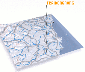 Places with similar names to Trai Ðồng Nông, Vietnam :: Disclaimer :: Information on this page comes without warranty of any kind |
||
|
Where is Trai Ðồng Nông? Elevation and coordinates ::
Latitude (lat): 19°9'0"N Longitude (lon): 105°30'0"E
Elevation (approx.): 54m (map arrows pan, magnifying glasses zoom) |
||
|
Visiting Trai Ðồng Nông? Hotel/Accommodation ::
Book a hotel in Trai Ðồng Nông Travel Guide ::
Buy a travel guide for Vietnam rental cars ::
car rental offers GPS waypoint ::
download a GPX waypoint (PoI) of Trai Ðồng Nông for your GPS receiver
|
||