|
search place name
|
||
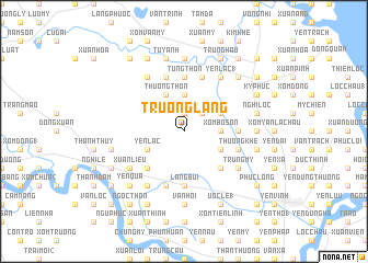
Trương Lãng (Vietnam)Trương Lãng is a town in Vietnam. An overview map of the region around Trương Lãng is displayed below.
regional and 3d topo map of Trương Lãng, Vietnam ::
Trương Lãng airports ::
The nearest airport is SNO - Sakon Nakhon, located 230.3 km south west of Trương Lãng.
Nearby towns ::
Son Lâng (1.9km north) //
Thạch Tiền (2.6km north east) //
Xóm Xuân Tan (2.6km north east) //
Xóm Bố Sơn (3.5km east) //
Ðông Thôn (3.7km north) //
Yên Lạc (4.0km south west) //
Lô Ðiên (4.0km south east) //
Thượng Thôn (4.1km north west) //
Xóm Phuc Thọ (4.0km north east) //
Làng Ða Lac (5.1km south west) //
Hạ Khê (5.1km south east) //
Khoa Ðà (5.1km south east) //
Bui Thôn (5.6km north) //
Tung Thôn (5.6km north) //
Hưng Thịnh (5.3km east) //
Làng Bui (5.6km south) //
Hữu Biêt (5.6km south) //
Thương Khê (5.6km east) //
Truyên Thôn (5.8km north) //
Ló Tương (5.8km north) //
Hoàng Trù (5.8km south) //
Khoa Cử (5.8km south) //
Thiều Xá (1) (5.8km north) //
Ðông Thôn (5.8km north) //
Trung Mỹ (6.4km south east) //
Mỹ Hậu (6.4km south east) //
Nguyệt Tỉnh (6.6km north west) //
Gia Lạc (6.6km south west) //
Kim Liêu (6.6km south west) //
[all distances 'as the bird flies' and approximate]  Places with similar names to Trương Lãng, Vietnam ::
// Trung Lăng (VN)
// Trung Lương (VN)
// Trung Lương (VN)
// Trung Lương (VN)
// Trung Lương (VN)
// Trung Lương (VN)
// Trường Long (VN)
// Drinkeling (BE)
Disclaimer :: Information on this page comes without warranty of any kind |
||
|
Where is Trương Lãng? Elevation and coordinates ::
Latitude (lat): 18°44'0"N Longitude (lon): 105°35'0"E
Elevation (approx.): 14m (map arrows pan, magnifying glasses zoom) |
||
|
Visiting Trương Lãng? Hotel/Accommodation ::
Book a hotel in Trương Lãng Travel Guide ::
Buy a travel guide for Vietnam rental cars ::
car rental offers GPS waypoint ::
download a GPX waypoint (PoI) of Trương Lãng for your GPS receiver
|
||