|
search place name
|
||
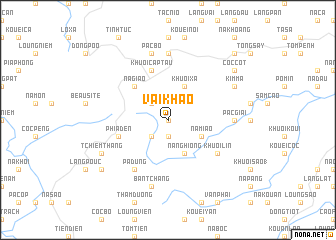
Vài Khao (Cao Bằng, Vietnam)Vài Khao is a town in the Cao Bằng region of Vietnam. An overview map of the region around Vài Khao is displayed below.
regional and 3d topo map of Vài Khao, Vietnam ::
Vài Khao airports ::
The nearest airport is HAN - Hanoi Noibai Intl, located 151.4 km south of Vài Khao.
Nearby towns ::
Nà Rỏng (0.0km north) //
Na Cap (1.9km south) //
Phiêng Tăng (2.5km south west) //
Làng Mười (2.5km north west) //
Nà Nghiống (4.1km south east) //
Na Miao (3.9km south east) //
Bản Young (4.1km north east) //
Khuổi Xả (4.1km north east) //
Nà Giảo (5.0km north west) //
Phia Ðén (5.5km west) //
Khuổi Cap Tau (5.8km north) //
Khuổi Lin (6.3km south east) //
Pá Dưng (6.5km south west) //
Nguyên Bình (7.4km north) //
Pac Giài (6.8km east) //
Bản Tchang (7.6km south) //
Pac Bó (7.6km north) //
Tchiem Thang (7.8km south west) //
Kim Mã (7.8km north east) //
Khau Vài (8.8km south west) //
Cốc Cot (8.8km north east) //
Linh Kouang (10.1km north east) //
[all distances 'as the bird flies' and approximate] 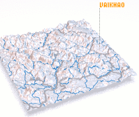 Places with similar names to Vài Khao, Vietnam ::
Disclaimer :: Information on this page comes without warranty of any kind |
||
|
Where is Vài Khao? Elevation and coordinates ::
Latitude (lat): 22°35'0"N Longitude (lon): 105°56'0"E
Elevation (approx.): 1105m (map arrows pan, magnifying glasses zoom) |
||
|
Visiting Vài Khao? Hotel/Accommodation ::
Book a hotel in Vài Khao Travel Guide ::
Buy a travel guide for Vietnam rental cars ::
car rental offers GPS waypoint ::
download a GPX waypoint (PoI) of Vài Khao for your GPS receiver
|
||