|
search place name
|
||
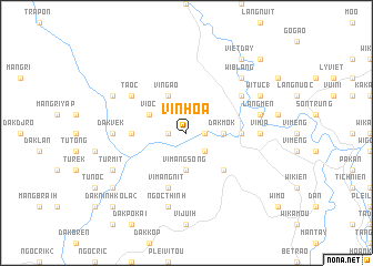
Vin Hoa (Vietnam)Vin Hoa is a town in Vietnam. An overview map of the region around Vin Hoa is displayed below.
regional and 3d topo map of Vin Hoa, Vietnam ::
Vin Hoa airports ::
The nearest airport is DAD - Danang Intl, located 115.1 km north of Vin Hoa.
Nearby towns ::
Windjia (1.8km east) //
Vin Dia (1.8km west) //
Long Tine (2.6km south east) //
Dak Mok (3.6km east) //
Vimang Song (3.7km south) //
Vingao (4.1km north west) //
Vi Oc (4.0km north west) //
Ngoc Tua (5.2km south east) //
Calok (5.4km east) //
Dak Mu (5.4km west) //
Vimang Nit (5.8km south) //
Chuc Cat (6.5km north east) //
Camen (6.5km north east) //
Tã Oc (6.5km north west) //
Tayou (6.5km north east) //
Vimia (7.2km east) //
Dak Vek (7.2km west) //
Làng Men (7.4km east) //
Ngoc Thinh (7.6km south) //
Wi Blang (7.7km north east) //
Ban Muy (7.7km north east) //
Wi Tuc (1) (8.1km north east) //
Mang Kola (8.1km north west) //
Turmit (8.1km south west) //
Viet Day (9.2km north east) //
Dak Klong (9.1km south west) //
Bayado (10.3km north east) //
Dak Ninh Kola (2) (10.3km south west) //
[all distances 'as the bird flies' and approximate]  Places with similar names to Vin Hoa, Vietnam ::
Disclaimer :: Information on this page comes without warranty of any kind |
||
|
Where is Vin Hoa? Elevation and coordinates ::
Latitude (lat): 15°1'0"N Longitude (lon): 108°22'0"E
Elevation (approx.): 154m (map arrows pan, magnifying glasses zoom) |
||
|
Visiting Vin Hoa? Hotel/Accommodation ::
Book a hotel in Vin Hoa Travel Guide ::
Buy a travel guide for Vietnam rental cars ::
car rental offers GPS waypoint ::
download a GPX waypoint (PoI) of Vin Hoa for your GPS receiver
|
||