|
search place name
|
||
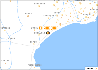
Changqian (Zhejiang, China)Changqian is a town in the Zhejiang region of China. An overview map of the region around Changqian is displayed below.
regional and 3d topo map of Changqian, China ::
Changqian airports ::
The nearest airport is HGH - Hangzhou Xiaoshan, located 63.6 km south west of Changqian.
Other airports nearby include SHA - Shanghai Hongqiao Intl (79.4 km north east), NGB - Ninbo Lishe (92.5 km south east), Nearby towns ::
Baizhuzhen (3.2km west) //
Haitang (3.7km north east) //
Sunjiaxu (5.5km north east) //
Yuanjiatou (5.3km north east) //
Dayunsi (5.1km west) //
Jinghai (5.6km north east) //
Xitangqiao (6.4km north) //
Wuyuan (6.1km south west) //
Wangzhuangqiao (6.6km north east) //
Shuguangqiao (7.6km north) //
Shengfengqiao (7.7km north east) //
Xieqiao (8.0km north) //
Zhengjiadai (7.4km north east) //
Xiaoxujiao (8.2km north east) //
Xin'andongqiao (8.8km north east) //
Sujiatou (8.9km north east) //
Lujiabang (9.4km north east) //
Xinhuang (10.1km north west) //
Wangdianqiao (10.2km north east) //
Tangjiatou (10.9km north east) //
[all distances 'as the bird flies' and approximate]  Places with similar names to Changqian, China ::
// Chenkeken (MX)
// Chungok-ni (KR)
// Shang-kuan (TW)
// Shang'aicun (CN)
// Changcun (CN)
// Changcun (CN)
// Changcun (CN)
// Changcun (CN)
// Changcun (CN)
// Changcun (CN)
Disclaimer :: Information on this page comes without warranty of any kind |
||
|
Where is Changqian? Elevation and coordinates ::
Latitude (lat): 30°33'0"N Longitude (lon): 120°59'0"E
Elevation (approx.): -32768m (map arrows pan, magnifying glasses zoom) |
||
|
Visiting Changqian? Hotel/Accommodation ::
Book a hotel in Changqian Travel Guide ::
Buy a travel guide for China rental cars ::
car rental offers GPS waypoint ::
download a GPX waypoint (PoI) of Changqian for your GPS receiver
|
||