|
search place name
|
||
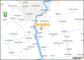
Chenhang (Shanghai, China)Chenhang is a town in the Shanghai region of China. An overview map of the region around Chenhang is displayed below.
regional and 3d topo map of Chenhang, China ::
Chenhang airports ::
The nearest airport is SHA - Shanghai Hongqiao Intl, located 15.7 km north west of Chenhang.
Other airports nearby include HGH - Hangzhou Xiaoshan (141.9 km south west), NGB - Ninbo Lishe (144.9 km south), Nearby towns ::
Sanlin (1.6km north east) //
Luwan (2.2km south west) //
Yangsiqiao (3.1km north) //
Gangkou (3.2km west) //
Guangang (4.1km south) //
Longhua (4.4km north west) //
Houtan (5.6km north) //
Yujiaqiao (5.1km south east) //
Zhoujiadu (6.0km north) //
Xuhui (5.4km west) //
Bailianjing (6.5km north) //
Liuliqiao (6.8km north east) //
Tangqiao (7.3km north) //
Caohang (6.8km south west) //
Wujing (7.6km south) //
Caohejing (7.0km north west) //
Nanshi (7.9km north) //
Zhangqiao (7.9km north) //
Xujiahui (8.0km north west) //
Duhang (8.6km south) //
Beicai (8.8km north east) //
Tangwan (9.5km south west) //
Shaojialou (9.2km south east) //
[all distances 'as the bird flies' and approximate] 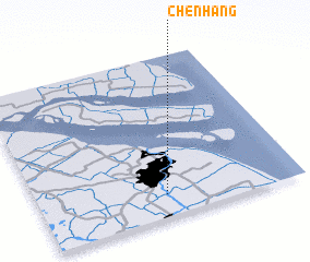 Places with similar names to Chenhang, China ::
Disclaimer :: Information on this page comes without warranty of any kind |
||
|
Where is Chenhang? Elevation and coordinates ::
Latitude (lat): 31°8'0"N Longitude (lon): 121°29'0"E
Elevation (approx.): 2m (map arrows pan, magnifying glasses zoom) |
||
|
Visiting Chenhang? Hotel/Accommodation ::
Book a hotel in Chenhang Travel Guide ::
Buy a travel guide for China rental cars ::
car rental offers GPS waypoint ::
download a GPX waypoint (PoI) of Chenhang for your GPS receiver
|
||