|
search place name
|
||
Huangang (Jiangsu, China)Huangang is a town in the Jiangsu region of China. An overview map of the region around Huangang is displayed below.
regional and 3d topo map of Huangang, China ::

Huangang airports ::
The nearest airport is NKG - Nanjing Lukou, located 253.2 km south west of Huangang.
Nearby towns ::
Xiaochazi (3.7km south) //
Zhongxingzhen (5.6km north) //
Xiaonanhuai (5.4km south west) //
Hexing (5.9km north east) //
Mutouwuzi (6.2km west) //
Hede (7.4km north east) //
Daliujiu (8.0km north west) //
Chenyang (7.7km north west) //
Zhongxingqiao (8.7km south east) //
Anwa (9.0km south west) //
[all distances 'as the bird flies' and approximate] 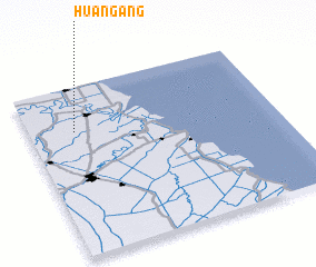 Places with similar names to Huangang, China ::
// Huanggang (CN)
// Han'gang (CN)
// Han-k'eng (TW)
// Han-k'eng (TW)
// Hiên Ngang (VN)
// Hoang Giang (VN)
// Hoàng Ngà (VN)
// Hong Ngai (VN)
// Hong Ngài (VN)
// Hồng Ngự (VN)
Disclaimer :: Information on this page comes without warranty of any kind |
||
|
Where is Huangang? Elevation and coordinates ::
Latitude (lat): 33°44'0"N Longitude (lon): 120°11'0"E
Elevation (approx.): 1m (map arrows pan, magnifying glasses zoom) |
||
|
Visiting Huangang? Hotel/Accommodation ::
Book a hotel in Huangang Travel Guide ::
Buy a travel guide for China rental cars ::
car rental offers GPS waypoint ::
download a GPX waypoint (PoI) of Huangang for your GPS receiver
|
||