|
search place name
|
||
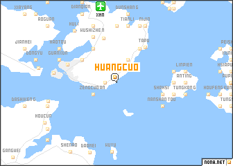
Huangcuo (Fujian, China)Huangcuo is a town in the Fujian region of China. An overview map of the region around Huangcuo is displayed below.
regional and 3d topo map of Huangcuo, China ::
nearby GPS traces from timatio ::
Huangcuo airports ::
The nearest airport is XMN - Xiamen Gaoqi, located 12.5 km north of Huangcuo.
Other airports nearby include KNH - Chinmen Shang Yi (21.2 km east), MZG - Makung Magong (178.3 km south east), WOT - Wang An (180.5 km south east), FOC - Fuzhou Changle (225.7 km north east), Nearby towns ::
Tatou (1.7km west) //
Jiazaiwei (3.9km south west) //
Zengcuo'an (3.9km south west) //
Qiancun (4.1km north east) //
Hecuo (6.5km north east) //
Lianfan (6.5km north west) //
Jiangtou (6.5km north west) //
Xiamenzhan (6.3km north west) //
Tapu (7.1km north east) //
Heshan (7.5km north) //
Ch'ing-ch'i (7.0km east) //
Sha-hsi (7.0km east) //
Nan-shan-t'ou (7.7km south east) //
Wushizhen (8.1km north west) //
Xiamen (7.8km west) //
Huli (10.4km north west) //
[all distances 'as the bird flies' and approximate] 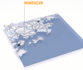 Places with similar names to Huangcuo, China ::
Disclaimer :: Information on this page comes without warranty of any kind |
||
|
Where is Huangcuo? Elevation and coordinates ::
Latitude (lat): 24°26'0"N Longitude (lon): 118°9'0"E
Elevation (approx.): -32768m (map arrows pan, magnifying glasses zoom) |
||
|
Visiting Huangcuo? Hotel/Accommodation ::
Book a hotel in Huangcuo Travel Guide ::
Buy a travel guide for China rental cars ::
car rental offers GPS waypoint ::
download a GPX waypoint (PoI) of Huangcuo for your GPS receiver
|
||