|
search place name
|
||
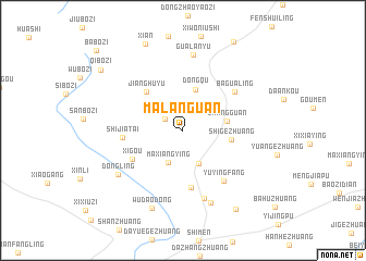
Malanguan (Hebei, China)Malanguan is a town in the Hebei region of China. An overview map of the region around Malanguan is displayed below.
regional and 3d topo map of Malanguan, China ::
Malanguan airports ::
The nearest airport is PEK - Beijing Capital Intl, located 94.5 km west of Malanguan.
Other airports nearby include TSN - Tianjin Binhai (124.2 km south), Nearby towns ::
Xiqu (1.8km north west) //
Maxiangying (3.5km south) //
Malanyu (3.6km south) //
Dongqu (4.3km north) //
Shangguan (3.6km east) //
Shigezhuang (3.9km east) //
Jianghuyu (4.9km north west) //
Xigou (4.9km south west) //
Xinglongquan (5.9km south) //
Shijiatai (4.8km west) //
Bagualing (5.6km north east) //
Yuyingfang (6.1km south east) //
Nanxincheng (7.2km south) //
Gualanyu (7.8km north) //
Xincheng (7.7km south) //
Dongling (6.8km south west) //
Wudaodong (8.4km south) //
Xiaoxinzhuang (9.1km south east) //
Qibozi (8.9km north west) //
Babozi (10.6km north west) //
[all distances 'as the bird flies' and approximate]  Places with similar names to Malanguan, China ::
// Melingon (MM)
// Milaunggon (MM)
// Milaunggon (MM)
// Milaunggon (MM)
// Milaunggon (MM)
// Milaunggon (MM)
// Milaunggôn (MM)
// Milaungon (MM)
// Maalngon (PH)
// Malangan (PH)
Disclaimer :: Information on this page comes without warranty of any kind |
||
|
Where is Malanguan? Elevation and coordinates ::
Latitude (lat): 40°12'47"N Longitude (lon): 117°40'49"E
Elevation (approx.): 116m (map arrows pan, magnifying glasses zoom) |
||
|
Visiting Malanguan? Hotel/Accommodation ::
Book a hotel in Malanguan Travel Guide ::
Buy a travel guide for China rental cars ::
car rental offers GPS waypoint ::
download a GPX waypoint (PoI) of Malanguan for your GPS receiver
|
||