|
search place name
|
||
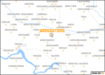
Wanggutong (Anhui, China)Wanggutong is a town in the Anhui region of China. An overview map of the region around Wanggutong is displayed below.
regional and 3d topo map of Wanggutong, China ::
Wanggutong airports ::
The nearest airport is HFE - Hefei Luogang, located 160.9 km south east of Wanggutong.
Nearby towns ::
Wangzhuangzi (2.4km south west) //
Dongzhuang (3.7km south) //
Jiangbeidian (4.2km north east) //
Banji (4.8km north east) //
Yangzhuang (4.3km north west) //
Yaolou (5.6km north) //
Xilou (4.7km west) //
Maxu (4.7km east) //
Yanglou (5.8km south) //
Manxuzi (5.6km south east) //
Qianningzhuang (6.8km north west) //
Guoxu (6.6km north east) //
Wujiang (7.5km south) //
Laomiaoji (8.0km north west) //
Wangyaozhuang (7.2km north west) //
Zhuxiaozhuang (7.9km south east) //
Tanggou (8.8km south west) //
[all distances 'as the bird flies' and approximate]  Places with similar names to Wanggutong, China ::
// Wangtenga (BF)
// Wanagading (ID)
// Wangding (SD)
// Hwanghak-tong (KP)
// Hwangŏ-dong (KP)
// Hwangŏ-dong (KP)
// Wangdang (KP)
// Hwang-dong (KR)
// Wang-dong (KR)
// Hwang-dong (KP)
Disclaimer :: Information on this page comes without warranty of any kind |
||
|
Where is Wanggutong? Elevation and coordinates ::
Latitude (lat): 32°52'0"N Longitude (lon): 116°10'0"E
Elevation (approx.): 29m (map arrows pan, magnifying glasses zoom) |
||
|
Visiting Wanggutong? Hotel/Accommodation ::
Book a hotel in Wanggutong Travel Guide ::
Buy a travel guide for China rental cars ::
car rental offers GPS waypoint ::
download a GPX waypoint (PoI) of Wanggutong for your GPS receiver
|
||