|
search place name
|
||
‘Adan aş Şafā (Ta‘izz, Yemen)‘Adan aş Şafā is a town in the Ta‘izz region of Yemen. An overview map of the region around ‘Adan aş Şafā is displayed below.
regional and 3d topo map of ‘Adan aş Şafā, Yemen ::
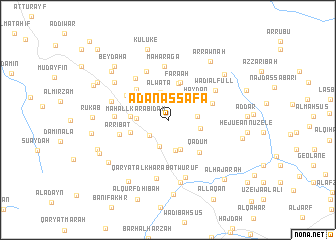
Nearby towns ::
Al Qundhūf (2.7km south west) //
Az̧ Z̧āji‘ (3.1km south) //
Al Waţāʼ (3.2km north) //
Al Gube (3.2km east) //
Maḩall Karābidah (3.5km west) //
Al Az̧būr (3.6km south) //
Dār al Wādī (3.6km south east) //
Hadīz̧ah (3.7km north west) //
Al ‘Amarah (3.6km east) //
Karabda al Ketf (3.9km north east) //
Ḩaydān (3.9km north east) //
Ad Dalīfah (4.0km north east) //
Al Ḩayşān (4.0km west) //
Farā‘ah (4.3km north) //
Sūq al Khamīs (4.4km north) //
Alqīr (4.3km west) //
Al Mar‘āmah (4.6km north west) //
Al Ghawl (4.8km north west) //
Qadūm (5.0km south east) //
Aţ Ţiwāl (5.2km east) //
Banī Sayf (5.3km north west) //
Ar Ribāţ (5.6km west) //
Al ‘Arūd (5.8km north west) //
Mīrāb (5.8km north west) //
Al ‘Āwah (5.8km west) //
Maharaga (6.0km north) //
Wādī al Full (6.1km north east) //
Ash Shiqqah (6.5km west) //
Qaryat al Kharābat Wuruf (6.7km south) //
[all distances 'as the bird flies' and approximate] 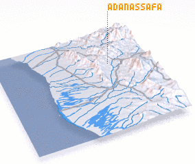 Places with similar names to ‘Adan aş Şafā, Yemen ::
// Atanasovo (BG)
Disclaimer :: Information on this page comes without warranty of any kind |
||
|
Where is ‘Adan aş Şafā? Elevation and coordinates ::
Latitude (lat): 13°41'46"N Longitude (lon): 43°45'14"E
Elevation (approx.): 1023m (map arrows pan, magnifying glasses zoom) |
||
|
Visiting ‘Adan aş Şafā? Hotel/Accommodation ::
Book a hotel in ‘Adan aş Şafā Travel Guide ::
Buy a travel guide for Yemen rental cars ::
car rental offers GPS waypoint ::
download a GPX waypoint (PoI) of ‘Adan aş Şafā for your GPS receiver
|
||