|
search place name
|
||
Ad Daghah (Yemen)Ad Daghah is a town in Yemen. An overview map of the region around Ad Daghah is displayed below.
regional and 3d topo map of Ad Daghah, Yemen ::
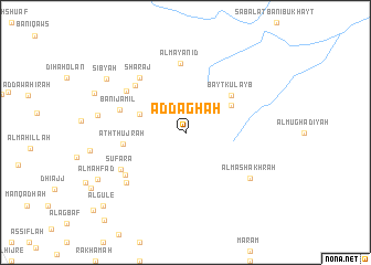
Nearby towns ::
Ridā‘ (4.8km west) //
Al Baradūn (5.3km north east) //
Bayt Kulayb (5.8km north east) //
Ath Thujrah (6.3km west) //
Sibāl al Ḩadīd (6.8km north west) //
Al Mayānid (7.0km north) //
Banī Jamīl (6.8km west) //
Sharaj (7.1km north west) //
Banī ‘Akrūt (7.1km north west) //
Sufara (7.3km south west) //
Al Quḑāḑah (7.3km south west) //
Bishār (7.7km south west) //
Al Mashākhrah (7.8km south east) //
Sibyah (9.4km north west) //
Al Maḩfad (9.8km south west) //
Al Gule (11.0km south west) //
[all distances 'as the bird flies' and approximate] 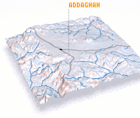 Places with similar names to Ad Daghah, Yemen ::
Disclaimer :: Information on this page comes without warranty of any kind |
||
|
Where is Ad Daghah? Elevation and coordinates ::
Latitude (lat): 14°42'0"N Longitude (lon): 44°32'30"E
Elevation (approx.): 2557m (map arrows pan, magnifying glasses zoom) |
||
|
Visiting Ad Daghah? Hotel/Accommodation ::
Book a hotel in Ad Daghah Travel Guide ::
Buy a travel guide for Yemen rental cars ::
car rental offers GPS waypoint ::
download a GPX waypoint (PoI) of Ad Daghah for your GPS receiver
|
||