|
search place name
|
||
Al Qamā (‘Adan, Yemen)Al Qamā is a town in the ‘Adan region of Yemen. An overview map of the region around Al Qamā is displayed below.
regional and 3d topo map of Al Qamā, Yemen ::

Al Qamā airports ::
The nearest airport is EAM - Nejran, located 113.5 km north east of Al Qamā.
Other airports nearby include GIZ - Gizan King Abdullah Bin Abdulaziz (126.3 km west), AHB - Abha (198.3 km north west), Nearby towns ::
Dhū Ghīlān (1.9km south) //
Al Kharāb (2.6km south west) //
Sibālah (4.1km north west) //
Khiyām Saḩḩār (4.0km south west) //
Nawfān (5.1km south west) //
Aţ Ţulūl (5.8km north) //
Qā‘ ad Darb (5.8km north) //
Aş Şafrāʼ (7.1km east) //
Wādi‘ah (7.6km north) //
Qaryat ash Sharaf (7.7km north west) //
Al Ḩaşaf (8.2km south west) //
Aş Şama‘ (9.0km north west) //
[all distances 'as the bird flies' and approximate] 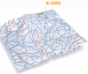 Places with similar names to Al Qamā, Yemen ::
Disclaimer :: Information on this page comes without warranty of any kind |
||
|
Where is Al Qamā? Elevation and coordinates ::
Latitude (lat): 16°48'0"N Longitude (lon): 43°46'0"E
Elevation (approx.): 2032m (map arrows pan, magnifying glasses zoom) |
||
|
Visiting Al Qamā? Hotel/Accommodation ::
Book a hotel in Al Qamā Travel Guide ::
Buy a travel guide for Yemen rental cars ::
car rental offers GPS waypoint ::
download a GPX waypoint (PoI) of Al Qamā for your GPS receiver
|
||