|
search place name
|
||
Banī Dimāj (‘Adan, Yemen)Banī Dimāj is a town in the ‘Adan region of Yemen. An overview map of the region around Banī Dimāj is displayed below.
regional and 3d topo map of Banī Dimāj, Yemen ::

Nearby towns ::
Al ‘Ark (1.9km south) //
Al Jurayfah (2.6km north east) //
Qurayni‘ (4.1km south east) //
Mihrabah (4.1km south east) //
Jeniaie (4.1km south west) //
Zirab (5.6km north) //
Kashe (5.6km north) //
Kramie (5.8km north) //
Akamah (5.8km north) //
Adamāt (5.8km north) //
Shaykh ‘Ubayd (5.7km west) //
Qamā‘irah (6.6km south east) //
Sūq Aḩad (6.6km south west) //
‘Abdān (7.4km east) //
Al Baţlāḩ (7.6km south) //
Ad Dūl (7.6km west) //
Sufyān (8.2km south east) //
Shayḩān (8.1km south west) //
Sākin (8.1km south west) //
Sūq (8.2km north east) //
Bayt ‘Ubaydān (8.3km south east) //
Ad Dahhān (9.2km north east) //
Al Ḩaḑrā (10.3km north west) //
[all distances 'as the bird flies' and approximate] 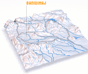 Places with similar names to Banī Dimāj, Yemen ::
Disclaimer :: Information on this page comes without warranty of any kind |
||
|
Where is Banī Dimāj? Elevation and coordinates ::
Latitude (lat): 13°42'0"N Longitude (lon): 44°16'0"E
Elevation (approx.): 1389m (map arrows pan, magnifying glasses zoom) |
||
|
Visiting Banī Dimāj? Hotel/Accommodation ::
Book a hotel in Banī Dimāj Travel Guide ::
Buy a travel guide for Yemen rental cars ::
car rental offers GPS waypoint ::
download a GPX waypoint (PoI) of Banī Dimāj for your GPS receiver
|
||