|
search place name
|
||
Ḩabbān (‘Adan, Yemen)Ḩabbān is a town in the ‘Adan region of Yemen. An overview map of the region around Ḩabbān is displayed below.
regional and 3d topo map of Ḩabbān, Yemen ::
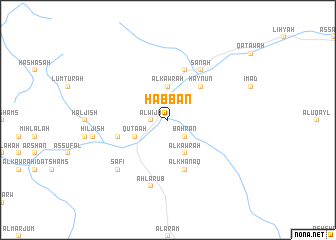
Nearby towns ::
Al Wijāʼ (1.8km west) //
Ḩişn Şāliḩ Bin ‘Uthmān (2.6km north west) //
Al Ḩumayrah (2.6km north east) //
Baḩrān (2.6km south east) //
Masann (3.7km north) //
Al Kawrah (3.7km north) //
Al Kawrah (4.1km south east) //
Quţa‘ah (4.0km south west) //
Haynūn (5.2km north east) //
Ribāţ Banī Shaqqā‘ (5.7km west) //
Al Khanaq (5.8km south) //
Al ‘Aram (5.8km north) //
Sanah (6.6km north east) //
Quwayrah (6.6km north east) //
Ahl ‘Arūb (7.6km south) //
Şāfī (7.7km south west) //
Hiljish (8.3km west) //
[all distances 'as the bird flies' and approximate]  Places with similar names to Ḩabbān, Yemen ::
Disclaimer :: Information on this page comes without warranty of any kind |
||
|
Where is Ḩabbān? Elevation and coordinates ::
Latitude (lat): 14°21'0"N Longitude (lon): 47°5'0"E
Elevation (approx.): 964m (map arrows pan, magnifying glasses zoom) |
||
|
Visiting Ḩabbān? Hotel/Accommodation ::
Book a hotel in Ḩabbān Travel Guide ::
Buy a travel guide for Yemen rental cars ::
car rental offers GPS waypoint ::
download a GPX waypoint (PoI) of Ḩabbān for your GPS receiver
|
||