|
search place name
|
||
Ḩumarah (Ta‘izz, Yemen)Ḩumarah is a town in the Ta‘izz region of Yemen. An overview map of the region around Ḩumarah is displayed below.
regional and 3d topo map of Ḩumarah, Yemen ::

Nearby towns ::
Maqrabah (1.6km north west) //
Al Alwāḩ (2.2km south) //
Al Ḩaymatayn (2.5km north west) //
Al Ḩumayrah (2.7km south east) //
Bayt al Hallidge (3.0km north east) //
Al Afzār (3.1km north) //
Khalīj (3.1km north east) //
Al Qar‘ah (3.7km south west) //
Hedmur (4.0km north) //
Qaryat al Ḩumayrāʼ (3.9km south west) //
Ad Dumaynah (4.3km east) //
Al Jarf (4.4km west) //
Al ‘Āmirah (4.5km north east) //
Al Qayrāf (4.9km south) //
As Salāmah (5.1km north west) //
Biʼr Bāshah (5.1km east) //
Qaryat al Marāgh (5.2km north) //
Kharābah (5.8km east) //
Tahun (6.0km east) //
Sabāt (6.2km north west) //
Madīnat an Nūr (6.2km east) //
‘Amirah (6.3km north east) //
Al Mibhā (6.5km south west) //
Shi‘b Ayūb (6.6km north east) //
Al Ghayl (6.7km north west) //
Geolane (6.7km north west) //
Al Ḩabīl (6.6km south east) //
Al Ḩurūf (6.7km north west) //
Barīhī (7.0km north east) //
[all distances 'as the bird flies' and approximate] 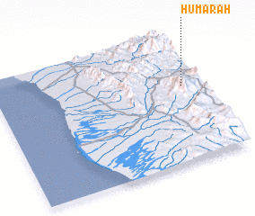 Places with similar names to Ḩumarah, Yemen ::
Disclaimer :: Information on this page comes without warranty of any kind |
||
|
Where is Ḩumarah? Elevation and coordinates ::
Latitude (lat): 13°35'52"N Longitude (lon): 43°55'48"E
Elevation (approx.): 1078m (map arrows pan, magnifying glasses zoom) |
||
|
Visiting Ḩumarah? Hotel/Accommodation ::
Book a hotel in Ḩumarah Travel Guide ::
Buy a travel guide for Yemen rental cars ::
car rental offers GPS waypoint ::
download a GPX waypoint (PoI) of Ḩumarah for your GPS receiver
|
||