|
search place name
|
||
Marfad (‘Adan, Yemen)Marfad is a town in the ‘Adan region of Yemen. An overview map of the region around Marfad is displayed below.
regional and 3d topo map of Marfad, Yemen ::

Nearby towns ::
Khawbar (1.3km north west) //
Lakmat ad Darb (1.7km south) //
Ad Darb (1.9km south) //
Al Munādī (1.8km west) //
Ḩabīl al Qubbah (2.6km north west) //
Dār Moshetaf (2.6km north west) //
Al ‘Utrīyā (2.6km north west) //
Al Ḩusayn (2.6km south east) //
Lakmat al Ash‘ūb (3.3km north) //
Ḩişn Ajra (3.3km south west) //
Al Qurayn (3.7km north) //
Jals (3.7km south) //
Al Khalīlī (3.6km east) //
Al Midsim (3.9km south east) //
Biʼr al Kūbah (4.1km north east) //
Al Jahda‘ah (4.1km north east) //
Nawbah (4.1km north east) //
Ḩayāz (4.1km south east) //
Al Miqţar (4.1km south west) //
Al Meydeybjib (5.2km south west) //
Dār Hajuf (5.2km south east) //
Sharīm (5.4km east) //
Khella (5.4km east) //
Al Ḩāzzah (5.4km west) //
Al ‘Uqlah (5.6km north) //
Dubar (5.7km west) //
Adh Dhahabī (5.7km west) //
Aş Şarifah (5.7km east) //
Al Ḩişwar (5.7km east) //
[all distances 'as the bird flies' and approximate] 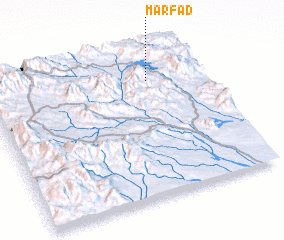 Places with similar names to Marfad, Yemen ::
Disclaimer :: Information on this page comes without warranty of any kind |
||
|
Where is Marfad? Elevation and coordinates ::
Latitude (lat): 13°48'0"N Longitude (lon): 44°45'0"E
Elevation (approx.): 1339m (map arrows pan, magnifying glasses zoom) |
||
|
Visiting Marfad? Hotel/Accommodation ::
Book a hotel in Marfad Travel Guide ::
Buy a travel guide for Yemen rental cars ::
car rental offers GPS waypoint ::
download a GPX waypoint (PoI) of Marfad for your GPS receiver
|
||