|
search place name
|
||
Ribāţ ‘Umrān (Yemen)Ribāţ ‘Umrān is a town in Yemen. An overview map of the region around Ribāţ ‘Umrān is displayed below.
regional and 3d topo map of Ribāţ ‘Umrān, Yemen ::
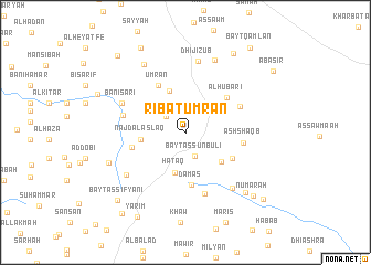
Nearby towns ::
Bayt as Sunbulī (2.5km south) //
Qurār (2.5km north west) //
Bayt al Kawmānī (2.9km north east) //
Banī Sārī (3.1km north) //
Ḩataq (4.2km south) //
Ḩusayn ‘Umrān (4.5km north) //
Najd al Aslāq (4.5km west) //
Al Khalaqah (4.6km south east) //
Damās (5.3km south) //
Bayt ‘Imrān (5.3km south east) //
Al Ḩubāri (5.4km north east) //
‘Umrān (5.5km north west) //
Ash Sharafah (5.5km west) //
Ash Shaqb (5.8km east) //
Shirah (6.0km north east) //
Al Wāsiţah (6.5km south) //
Al Qufl (6.4km west) //
Banī Sārī (6.9km north west) //
Ash Shalālah (7.2km south east) //
Dhī Jizub (7.3km north) //
Qu‘ayqi‘ān (7.2km south west) //
Dār al Ḩanish (7.8km north) //
Ad Dūr (7.9km north west) //
As Simlāl (8.1km west) //
Bayt Jubārī (8.4km south east) //
Al Qullah (9.3km north east) //
Numārah (9.3km south east) //
Ribāţ Qarz (9.6km north west) //
Wardasān (9.4km north west) //
[all distances 'as the bird flies' and approximate] 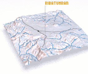 Places with similar names to Ribāţ ‘Umrān, Yemen :: Disclaimer :: Information on this page comes without warranty of any kind |
||
|
Where is Ribāţ ‘Umrān? Elevation and coordinates ::
Latitude (lat): 14°22'25"N Longitude (lon): 44°25'28"E
Elevation (approx.): 2520m (map arrows pan, magnifying glasses zoom) |
||
|
Visiting Ribāţ ‘Umrān? Hotel/Accommodation ::
Book a hotel in Ribāţ ‘Umrān Travel Guide ::
Buy a travel guide for Yemen rental cars ::
car rental offers GPS waypoint ::
download a GPX waypoint (PoI) of Ribāţ ‘Umrān for your GPS receiver
|
||