|
search place name
|
||
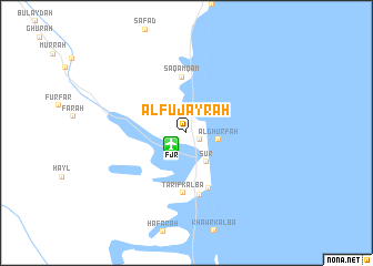
Al Fujayrah (Al Fujayrah, United Arab Emirates)Al Fujayrah is a town in the Al Fujayrah region of United Arab Emirates. An overview map of the region around Al Fujayrah is displayed below.
regional and 3d topo map of Al Fujayrah, United Arab Emirates ::
Al Fujayrah airports ::
The nearest airport is FJR - Fujeirah Fujairah Intl, located 1.8 km south west of Al Fujayrah.
Other airports nearby include RKT - Ras Al Khaimah Intl (67.5 km north west), SHJ - Sharjah Intl (85.7 km west), DXB - Dubai Intl (99.1 km west), KHS - Khasab (116.5 km north), Nearby towns ::
Rughaylāt (1.4km south east) //
Al Ghurfah (3.0km east) //
Şūr (3.4km south east) //
Saqamqam (5.6km north) //
Kalbā (5.9km south) //
Ţarīf Kalbā (6.1km south) //
Ḩayāt (6.4km south) //
[all distances 'as the bird flies' and approximate] 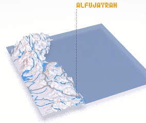 Places with similar names to Al Fujayrah, United Arab Emirates ::
Disclaimer :: Information on this page comes without warranty of any kind |
||
|
Where is Al Fujayrah? Elevation and coordinates ::
Latitude (lat): 25°7'23"N Longitude (lon): 56°20'15"E
Elevation (approx.): 21m (map arrows pan, magnifying glasses zoom) |
||
|
Visiting Al Fujayrah? Hotel/Accommodation ::
Book a hotel in Al Fujayrah Travel Guide ::
rental cars ::
car rental offers GPS waypoint ::
download a GPX waypoint (PoI) of Al Fujayrah for your GPS receiver
|
||