|
search place name
|
||
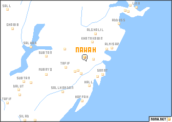
Nawah (Al Fujayrah, United Arab Emirates)Nawah is a town in the Al Fujayrah region of United Arab Emirates. An overview map of the region around Nawah is displayed below.
regional and 3d topo map of Nawah, United Arab Emirates ::
Nawah airports ::
The nearest airport is KHS - Khasab, located 38.2 km north of Nawah.
Other airports nearby include RKT - Ras Al Khaimah Intl (46.0 km south west), FJR - Fujeirah Fujairah Intl (80.1 km south), SHJ - Sharjah Intl (98.8 km south west), DXB - Dubai Intl (116.3 km south west), Nearby towns ::
Al Maḩallī (0.9km north) //
Raʼs al ‘Aqq (1.6km east) //
Sall Khawr (2.6km south west) //
Bayt Khawr (2.8km south) //
Al ‘Arqūb (3.2km south west) //
Khawr Ma‘lā (4.2km south east) //
Khaţm Kabīr (4.3km north) //
Sānāt (4.4km south east) //
Ţafīf (4.3km west) //
Ar Rawḑah (4.8km north west) //
‘Addas (4.8km north east) //
Ḩall (5.5km south) //
Al Mīsār (5.9km north east) //
Al Ghalīl (6.3km north) //
Sall Ḩamdān (8.2km south west) //
Ḩaffah (8.7km south) //
Subţān (7.9km west) //
Mubayq (8.3km west) //
Ad Duss (10.4km north east) //
[all distances 'as the bird flies' and approximate] 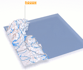 Places with similar names to Nawah, United Arab Emirates ::
Disclaimer :: Information on this page comes without warranty of any kind |
||
|
Where is Nawah? Elevation and coordinates ::
Latitude (lat): 25°50'7"N Longitude (lon): 56°19'36"E
Elevation (approx.): 456m (map arrows pan, magnifying glasses zoom) |
||
|
Visiting Nawah? Hotel/Accommodation ::
Book a hotel in Nawah Travel Guide ::
rental cars ::
car rental offers GPS waypoint ::
download a GPX waypoint (PoI) of Nawah for your GPS receiver
|
||