|
search place name
|
||
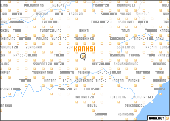
Kan-hsi (T'ai-wan, Taiwan)Kan-hsi is a town in the T'ai-wan region of Taiwan. An overview map of the region around Kan-hsi is displayed below.
regional and 3d topo map of Kan-hsi, Taiwan ::
Kan-hsi airports ::
The nearest airport is TSA - Taipei Sungshan, located 20.6 km north west of Kan-hsi.
Other airports nearby include TPE - Taipei Chiang Kai Shek Intl (51.6 km west), HUN - Hualien (107.0 km south), OGN - Yonaguni Jima Yonaguni (138.3 km south east), CYI - Chiayi (216.7 km south west), Nearby towns ::
Kan-mu-k'eng (1.7km west) //
Ta-she-hu (1.9km south) //
Yü-kuang (1.9km south) //
Tung-shih-ts'un (1.9km north) //
Fan-tzu-k'eng (1.7km east) //
Chang-ts'un (2.5km south west) //
Yü-kuei-ling (2.5km north west) //
Tung-shih-ko (2.5km north west) //
Huo-shao-liao (2.5km north east) //
Chiu-hsiung-k'eng (3.4km west) //
Pei-shih (3.7km south) //
Hu-liao-t'an (3.7km south) //
Tung-shih-ko (3.7km north) //
Fang-shan-k'eng (3.4km east) //
Shang-k'ang (3.8km south west) //
Ta-ts'u-k'eng (4.1km south west) //
Chiu-hsiung-k'eng (4.1km south west) //
Feng-t'ou (3.8km north west) //
Nan-shih-k'eng (3.8km north west) //
Ts'u-shih-hu (4.1km south east) //
Tung-kua-liao (4.1km north west) //
Hsiao-ts'u-k'eng (3.8km south east) //
Mei-tzu-liao (3.8km south east) //
K'uo-lai (3.8km south east) //
Kan-t'eng-lin (4.1km north east) //
P'an-shan-k'eng (3.8km north east) //
Shang-te (5.0km south west) //
Hsia-k'eng-tzu-k'ou (5.0km south west) //
K'eng-tzu-k'ou (5.0km south west) //
[all distances 'as the bird flies' and approximate]  Places with similar names to Kan-hsi, Taiwan ::
Disclaimer :: Information on this page comes without warranty of any kind |
||
|
Where is Kan-hsi? Elevation and coordinates ::
Latitude (lat): 24°59'0"N Longitude (lon): 121°44'0"E
Elevation (approx.): 372m (map arrows pan, magnifying glasses zoom) |
||
|
Visiting Kan-hsi? Hotel/Accommodation ::
Book a hotel in Kan-hsi Travel Guide ::
Buy a travel guide for Taiwan rental cars ::
car rental offers GPS waypoint ::
download a GPX waypoint (PoI) of Kan-hsi for your GPS receiver
|
||