|
search place name
|
||
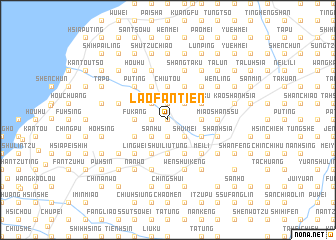
Lao-fan-tien (T'ai-wan, Taiwan)Lao-fan-tien is a town in the T'ai-wan region of Taiwan. An overview map of the region around Lao-fan-tien is displayed below.
regional and 3d topo map of Lao-fan-tien, Taiwan ::
Lao-fan-tien airports ::
The nearest airport is TPE - Taipei Chiang Kai Shek Intl, located 19.8 km north east of Lao-fan-tien.
Other airports nearby include TSA - Taipei Sungshan (46.5 km east), HUN - Hualien (112.9 km south east), CYI - Chiayi (178.8 km south west), MZW - Matsu Beigan (181.6 km north west), Nearby towns ::
Hsia-shui-wei (0.0km north) //
T'ou-hu (1.9km south) //
T'ien-hsin-tzu (1.9km north) //
Jui-yüan (1.7km west) //
Shui-mei (2.5km south east) //
Yang-mei (2.5km south east) //
San-hu (2.5km south west) //
T'ien-liao-tzu (2.5km north east) //
Ch'ing-ts'ao-p'o (2.5km north east) //
Yüan-pen (2.5km north west) //
Hung-wa-wu (2.5km north west) //
Peng-p'o (3.7km south) //
Shui-liu-tung (3.7km south) //
P'o-t'ang-wo (3.7km south) //
Kao-shan-ting (3.4km east) //
Kao-jung (3.4km east) //
Jui-yüan (3.4km west) //
Fu-kang (3.4km west) //
Chiu-tou (3.7km north) //
Shang-ch'ing-pu (3.7km north) //
Ta-p'ing (4.1km south east) //
Yüeh-mei (3.8km south east) //
Peng-p'o-hsia (4.1km south west) //
Liu-ku (3.8km north east) //
Shang-ssu-hu (3.8km south west) //
Shang-ch'ing-pu (4.1km north east) //
Pei-p'o (4.1km north east) //
Li-t'ou-chou (4.1km north east) //
Shih-p'o-hsia (4.1km north west) //
[all distances 'as the bird flies' and approximate]  Places with similar names to Lao-fan-tien, Taiwan ::
// La Fontaine (CH)
// La Fontaine (US)
// Lafontaine (US)
// Le Fontane (IT)
// Leeufontein (ZA)
// Leeuwfontein (ZA)
// Leeuwfontein (ZA)
// LaVentana (US)
// Livundoni (KE)
// La Ventana (MX)
Disclaimer :: Information on this page comes without warranty of any kind |
||
|
Where is Lao-fan-tien? Elevation and coordinates ::
Latitude (lat): 24°56'0"N Longitude (lon): 121°7'0"E
Elevation (approx.): 112m (map arrows pan, magnifying glasses zoom) |
||
|
Visiting Lao-fan-tien? Hotel/Accommodation ::
Book a hotel in Lao-fan-tien Travel Guide ::
Buy a travel guide for Taiwan rental cars ::
car rental offers GPS waypoint ::
download a GPX waypoint (PoI) of Lao-fan-tien for your GPS receiver
|
||