|
search place name
|
||
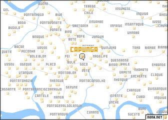
Capunga (Guinea-Bissau)Capunga is a town in Guinea-Bissau. An overview map of the region around Capunga is displayed below.
regional and 3d topo map of Capunga, Guinea-Bissau ::
Capunga airports ::
The nearest airport is BXO - Bissau Oswaldo Vieira Intl, located 24.7 km south of Capunga.
Other airports nearby include ZIG - Ziguinchor (81.2 km north west), CSK - Cap Skiring (120.1 km west), BJL - Banjul Intl (171.2 km north west), Nearby towns ::
Cabame (1.6km east) //
Sanhar (1.8km west) //
Biesse (1.9km south) //
Cacoque (1.8km west) //
Dôco (1.9km south) //
Nino (2.1km north west) //
Bedasse (2.2km south east) //
Petabe (2.4km north east) //
Pedara (2.6km north west) //
Ponta Alfama (2.6km south west) //
Blequisse (2.7km south west) //
Foncho (2.7km south east) //
Bissussum (3.0km north) //
Bula (3.0km south west) //
Pete (3.3km south) //
Madelife (3.6km east) //
Fei (3.6km west) //
Bulamete (3.6km west) //
Binhome (4.1km south east) //
Cacete (4.1km north west) //
Badápal (4.1km north west) //
Ponta J. Fona (4.1km south west) //
Ponta Soares (4.1km south west) //
Nhelma (4.1km south west) //
Ponta Umbrum (4.1km south west) //
Pubosse (4.1km south west) //
Choquemone (4.2km east) //
Bôfe (4.4km north) //
Botê (4.5km north west) //
[all distances 'as the bird flies' and approximate]  Places with similar names to Capunga, Guinea-Bissau ::
Disclaimer :: Information on this page comes without warranty of any kind |
||
|
Where is Capunga? Elevation and coordinates ::
Latitude (lat): 12°7'0"N Longitude (lon): 15°41'0"W
Elevation (approx.): 32m (map arrows pan, magnifying glasses zoom) |
||
|
Visiting Capunga? Hotel/Accommodation ::
Book a hotel in Capunga Travel Guide ::
rental cars ::
car rental offers GPS waypoint ::
download a GPX waypoint (PoI) of Capunga for your GPS receiver
|
||