|
search place name
|
||
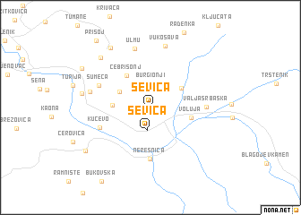
Ševica (Srbija, Serbia and Montenegro)Ševica is a town in the Srbija region of Serbia and Montenegro. An overview map of the region around Ševica is displayed below.
regional and 3d topo map of Ševica, Serbia and Montenegro ::
Ševica airports ::
The nearest airport is CSB - Caransebes, located 110.4 km north of Ševica.
Other airports nearby include BEG - Beograd (117.9 km west), INI - Nis (129.6 km south), TSR - Timisoara Traian Vuia (148.7 km north), ARW - Arad (189.9 km north), Nearby towns ::
Plješćicanji (2.2km north) //
Ševica (2.9km south) //
Burgionji (3.0km north) //
Marica (3.4km north west) //
Duboka (3.6km north east) //
Vrelo (3.4km west) //
Cebrišonj (4.5km north west) //
Voluja (3.8km east) //
Neresnica (6.4km south) //
Kučevo (5.1km south west) //
Valja Srbaska (5.0km east) //
Šumeća (5.3km north west) //
Ulmu (7.4km north) //
Tomonj (5.7km west) //
Vukosava (7.7km north) //
Pod Dulom (6.4km west) //
Rakova Bara (7.7km north west) //
Funjduri (8.2km north west) //
Kučajna (7.9km south west) //
Staro Selo (7.8km north west) //
Prisoj (9.6km north west) //
[all distances 'as the bird flies' and approximate] 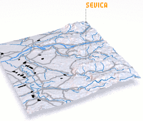 Places with similar names to Ševica, Serbia and Montenegro ::
Disclaimer :: Information on this page comes without warranty of any kind |
||
|
Where is Ševica? Elevation and coordinates ::
Latitude (lat): 44°30'0"N Longitude (lon): 21°43'36"E
Elevation (approx.): 198m (map arrows pan, magnifying glasses zoom) |
||
|
Visiting Ševica? Hotel/Accommodation ::
Book a hotel in Ševica Travel Guide ::
rental cars ::
car rental offers GPS waypoint ::
download a GPX waypoint (PoI) of Ševica for your GPS receiver
|
||