|
search place name
|
||
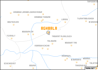
Aghbala (Beni Mellal, Morocco)Aghbala is a town in the Beni Mellal region of Morocco. An overview map of the region around Aghbala is displayed below.
regional and 3d topo map of Aghbala, Morocco ::
Aghbala airports ::
The nearest airport is ERH - Er-rachidia Moulay Ali Cherif, located 131.6 km south east of Aghbala.
Other airports nearby include MEK - Meknes Bassatine (155.6 km north), FEZ - Fez Saiss (172.1 km north), RBA - Rabat Sale (202.4 km north west), CMN - Casablanca Mohammed V Intl (206.8 km north west), Nearby towns ::
Taliouine (3.5km south) //
Taourirt-n-Lamlouch (4.5km east) //
Titene Bellel (5.3km south) //
Ksar Oumichcha (5.5km south) //
AïtAmar (5.9km north west) //
Tirhremt Ourhenoun (5.2km west) //
Kasba de Tihouna (6.2km north) //
Sidi Abd el Malek (6.4km north east) //
Bou Ourhzir (6.7km west) //
Lamsid (7.2km north east) //
Aït Ouidir (8.3km north) //
Bou Ouattas (8.2km south east) //
Aghbalou-n-Kerkouf (10.2km north west) //
Kasba de lʼArhbalou nʼKerkour (10.2km north west) //
[all distances 'as the bird flies' and approximate] 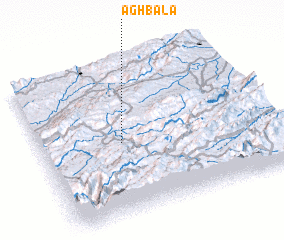 Places with similar names to Aghbala, Morocco ::
Disclaimer :: Information on this page comes without warranty of any kind |
||
|
Where is Aghbala? Elevation and coordinates ::
Latitude (lat): 32°28'50"N Longitude (lon): 5°38'42"W
Elevation (approx.): 1688m (map arrows pan, magnifying glasses zoom) |
||
|
Visiting Aghbala? Hotel/Accommodation ::
Book a hotel in Aghbala Travel Guide ::
Buy a travel guide for Morocco rental cars ::
car rental offers GPS waypoint ::
download a GPX waypoint (PoI) of Aghbala for your GPS receiver
|
||