|
search place name
|
||
Aguensou (Azilal, Morocco)Aguensou is a town in the Azilal region of Morocco. An overview map of the region around Aguensou is displayed below.
regional and 3d topo map of Aguensou, Morocco ::

Aguensou airports ::
The nearest airport is OZZ - Ouarzazate, located 68.4 km south of Aguensou.
Other airports nearby include RAK - Marrakech Menara (127.1 km west), CMN - Casablanca Mohammed V Intl (220.4 km north), Nearby towns ::
Tazgagalt (3.2km east) //
Imi nʼIsk (4.8km east) //
Idikel (6.8km north east) //
Iskad (8.1km north) //
Imi nʼOumfid (7.2km east) //
Khellal (8.5km north) //
Mellah (8.5km north) //
Tarbat nʼTirssal (8.9km north west) //
Abachkou (9.4km north east) //
Tisemt nʼIzri (10.0km south east) //
Timeourine (10.1km north west) //
Tamezrit (10.8km south east) //
Amezri (11.0km south east) //
[all distances 'as the bird flies' and approximate] 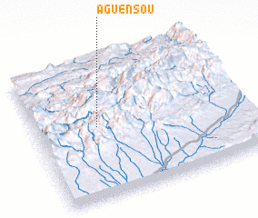 Places with similar names to Aguensou, Morocco ::
Disclaimer :: Information on this page comes without warranty of any kind |
||
|
Where is Aguensou? Elevation and coordinates ::
Latitude (lat): 31°31'44"N Longitude (lon): 6°42'1"W
Elevation (approx.): 2681m (map arrows pan, magnifying glasses zoom) |
||
|
Visiting Aguensou? Hotel/Accommodation ::
Book a hotel in Aguensou Travel Guide ::
Buy a travel guide for Morocco rental cars ::
car rental offers GPS waypoint ::
download a GPX waypoint (PoI) of Aguensou for your GPS receiver
|
||