|
search place name
|
||
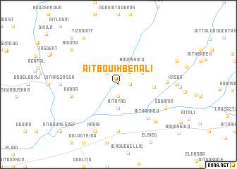
Aït Bouih Ben Ali (Taroudannt, Morocco)Aït Bouih Ben Ali is a town in the Taroudannt region of Morocco. An overview map of the region around Aït Bouih Ben Ali is displayed below.
regional and 3d topo map of Aït Bouih Ben Ali, Morocco ::
Aït Bouih Ben Ali airports ::
The nearest airport is AGA - Agadir Inezgane, located 38.2 km west of Aït Bouih Ben Ali.
Other airports nearby include RAK - Marrakech Menara (164.8 km north east), Nearby towns ::
Aït Skouala (1.9km south) //
Aït Hamida (1.6km east) //
El Ksiba (1.6km east) //
Aït Ahmimich (2.5km north east) //
Boudhar (2.4km north west) //
Amers (2.4km north west) //
Bou Assira (3.4km north east) //
Aït Ayad (3.7km south) //
Aït Azouz (3.7km north east) //
El Baarir Foukaniine (4.9km east) //
Aït Hammou (6.6km south east) //
Aït Belkassem (7.4km south) //
Riaïna (6.7km west) //
Naouji et Tahtaniine (6.7km east) //
Hadib (8.1km south west) //
Souanir (7.4km south east) //
Aïn el Beïda (7.7km south east) //
Bouria (8.5km north west) //
Tiziouint (8.8km north west) //
Sidi Mohand Ou Brahim (9.8km north west) //
[all distances 'as the bird flies' and approximate]  Places with similar names to Aït Bouih Ben Ali, Morocco :: Disclaimer :: Information on this page comes without warranty of any kind |
||
|
Where is Aït Bouih Ben Ali? Elevation and coordinates ::
Latitude (lat): 30°29'0"N Longitude (lon): 9°10'0"W
Elevation (approx.): 140m (map arrows pan, magnifying glasses zoom) |
||
|
Visiting Aït Bouih Ben Ali? Hotel/Accommodation ::
Book a hotel in Aït Bouih Ben Ali Travel Guide ::
Buy a travel guide for Morocco rental cars ::
car rental offers GPS waypoint ::
download a GPX waypoint (PoI) of Aït Bouih Ben Ali for your GPS receiver
|
||