|
search place name
|
||
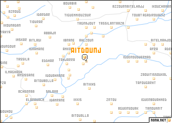
Aït Dounj (Essaouira, Morocco)Aït Dounj is a town in the Essaouira region of Morocco. An overview map of the region around Aït Dounj is displayed below.
regional and 3d topo map of Aït Dounj, Morocco ::
Aït Dounj airports ::
The nearest airport is AGA - Agadir Inezgane, located 55.7 km south of Aït Dounj.
Other airports nearby include RAK - Marrakech Menara (162.2 km north east), Nearby towns ::
Zaouiet Ouskour (0.0km north) //
Tiriouine (0.7km south west) //
Sidi Abdallah (2.8km north) //
Ahl Zoun (3.7km north) //
Aït Tiouine (3.7km south west) //
Amkouk (3.7km north west) //
Tamjarra (3.6km west) //
Sidi Bou Zid (4.2km south west) //
Sidi Mohamed Argrag (4.6km north west) //
Bou Zdoud (4.4km west) //
Ibrane (4.9km north west) //
Aït Tiouine (4.9km south west) //
Aksimine (5.6km north) //
Aït Ikhs (5.8km south) //
Sidi Ali Boubkar (6.3km north) //
Tasksil Sidi Ahmed (6.4km north east) //
Tagrajout (7.4km north) //
Imizer (7.6km north) //
Idou Ahmane (7.0km south west) //
Ed Dhar (7.2km west) //
Had Ida ou Mettat (8.8km south west) //
Tassila nʼTaâza (8.8km north east) //
Iguenouane (8.8km north east) //
Abbajn (8.6km north west) //
Salama (9.8km south west) //
[all distances 'as the bird flies' and approximate]  Places with similar names to Aït Dounj, Morocco ::
Disclaimer :: Information on this page comes without warranty of any kind |
||
|
Where is Aït Dounj? Elevation and coordinates ::
Latitude (lat): 30°53'0"N Longitude (lon): 9°31'0"W
Elevation (approx.): 558m (map arrows pan, magnifying glasses zoom) |
||
|
Visiting Aït Dounj? Hotel/Accommodation ::
Book a hotel in Aït Dounj Travel Guide ::
Buy a travel guide for Morocco rental cars ::
car rental offers GPS waypoint ::
download a GPX waypoint (PoI) of Aït Dounj for your GPS receiver
|
||