|
search place name
|
||
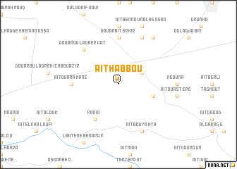
Aït Habbou (Azilal, Morocco)Aït Habbou is a town in the Azilal region of Morocco. An overview map of the region around Aït Habbou is displayed below.
regional and 3d topo map of Aït Habbou, Morocco ::
Aït Habbou airports ::
The nearest airport is RAK - Marrakech Menara, located 130.5 km south west of Aït Habbou.
Other airports nearby include OZZ - Ouarzazate (138.2 km south), CMN - Casablanca Mohammed V Intl (149.2 km north west), RBA - Rabat Sale (207.3 km north), MEK - Meknes Bassatine (224.8 km north east), Nearby towns ::
Oulad Ayad (3.6km north east) //
El Khemis des Oulad Ayad (3.6km north east) //
Aït Acco (5.1km east) //
Karia (6.4km south west) //
Douar Aït Srhir (7.4km north) //
Aït Ouaramane (6.3km west) //
Douar Oulad Berkat (7.3km north west) //
Aït Bou Yahya (8.1km south east) //
Douar Aït er Rami (8.0km north east) //
Douar Aït Ben Saïd (8.8km north east) //
[all distances 'as the bird flies' and approximate] 
Disclaimer :: Information on this page comes without warranty of any kind |
||
|
Where is Aït Habbou? Elevation and coordinates ::
Latitude (lat): 32°11'0"N Longitude (lon): 6°50'0"W
Elevation (approx.): 483m (map arrows pan, magnifying glasses zoom) |
||
|
Visiting Aït Habbou? Hotel/Accommodation ::
Book a hotel in Aït Habbou Travel Guide ::
Buy a travel guide for Morocco rental cars ::
car rental offers GPS waypoint ::
download a GPX waypoint (PoI) of Aït Habbou for your GPS receiver
|
||