|
search place name
|
||
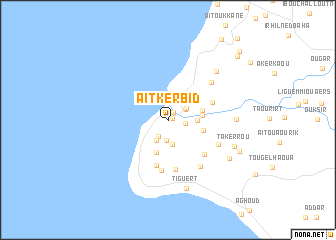
Aït Kerbid (Agadir, Morocco)Aït Kerbid is a town in the Agadir region of Morocco. An overview map of the region around Aït Kerbid is displayed below.
regional and 3d topo map of Aït Kerbid, Morocco ::
Aït Kerbid airports ::
The nearest airport is AGA - Agadir Inezgane, located 45.9 km south east of Aït Kerbid.
Other airports nearby include RAK - Marrakech Menara (200.5 km north east), Nearby towns ::
Aït Amer (0.5km north east) //
Id Ou Al Haj (1.0km north east) //
Id Ouchchene (1.7km east) //
Sihal (2.0km south west) //
Idourane (2.0km north east) //
Imriahene (2.3km south) //
Idourane (2.1km north east) //
Zaouit Sidi Brahim Ou Ali (2.5km south west) //
Imi nʼTghoula (2.8km south) //
Tamri (2.8km east) //
Aït Zekri (3.8km south) //
Ighraïn Ouamda (3.4km east) //
Ighraïn Ouamad (3.5km east) //
Id Bahemmouch (3.6km east) //
Aït Daoud (5.1km south) //
Mahmoud (4.7km north east) //
Tazemmourt (5.5km south) //
Id Ou Akchchoud (5.2km south east) //
Tagant (5.7km south) //
Agaraz (6.0km south east) //
Timzghouine (5.6km south east) //
Id er Raïs (5.9km north east) //
Timassinine (7.1km north east) //
Agoudi nʼAït Amer (6.6km east) //
Tiguert (7.8km south) //
Takerrou (7.0km south east) //
Adrar (7.3km south east) //
Ihnach (7.7km south east) //
Aït Ouchchane (9.7km north east) //
[all distances 'as the bird flies' and approximate]  Places with similar names to Aït Kerbid, Morocco :: Disclaimer :: Information on this page comes without warranty of any kind |
||
|
Where is Aït Kerbid? Elevation and coordinates ::
Latitude (lat): 30°41'53"N Longitude (lon): 9°51'17"W
Elevation (approx.): 130m (map arrows pan, magnifying glasses zoom) |
||
|
Visiting Aït Kerbid? Hotel/Accommodation ::
Book a hotel in Aït Kerbid Travel Guide ::
Buy a travel guide for Morocco rental cars ::
car rental offers GPS waypoint ::
download a GPX waypoint (PoI) of Aït Kerbid for your GPS receiver
|
||