|
search place name
|
||
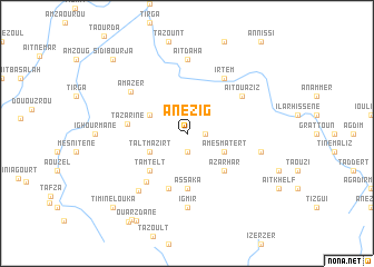
Anezig (Taroudannt, Morocco)Anezig is a town in the Taroudannt region of Morocco. An overview map of the region around Anezig is displayed below.
regional and 3d topo map of Anezig, Morocco ::
Anezig airports ::
The nearest airport is OZZ - Ouarzazate, located 124.7 km north east of Anezig.
Other airports nearby include RAK - Marrakech Menara (146.9 km north), AGA - Agadir Inezgane (152.3 km west), Nearby towns ::
Tamda (1.9km south) //
Tenerhch (1.6km east) //
Izoutern (3.7km south west) //
Taltmazirt (3.7km south west) //
Irhirhi (3.7km south west) //
Ifkrene (3.7km north west) //
Tafgart (3.7km south east) //
Amesmatert (3.7km south east) //
Tamtelt (4.9km south west) //
Azarhar (4.9km south east) //
Assaka (5.6km south) //
Idamkhene (5.8km south) //
Tazarine (5.3km west) //
Amzlou (6.0km south west) //
Aït Ouaziz (6.1km north east) //
Irtem (6.4km north east) //
Amazer (6.4km north west) //
Igmir (7.4km south) //
Aït Daha (7.4km north) //
Al Mdini (7.1km south west) //
Anammer (6.7km east) //
Ouarzdane (9.7km south west) //
Imi nʼTizgui (9.9km south west) //
Timine Louka (9.8km south west) //
Sidi Bou Rja (9.8km north west) //
Iouliouil (10.2km south west) //
[all distances 'as the bird flies' and approximate]  Places with similar names to Anezig, Morocco ::
Disclaimer :: Information on this page comes without warranty of any kind |
||
|
Where is Anezig? Elevation and coordinates ::
Latitude (lat): 30°17'0"N Longitude (lon): 7°58'0"W
Elevation (approx.): 1700m (map arrows pan, magnifying glasses zoom) |
||
|
Visiting Anezig? Hotel/Accommodation ::
Book a hotel in Anezig Travel Guide ::
Buy a travel guide for Morocco rental cars ::
car rental offers GPS waypoint ::
download a GPX waypoint (PoI) of Anezig for your GPS receiver
|
||