|
search place name
|
||
Ben Atmane (Taza, Morocco)Ben Atmane is a town in the Taza region of Morocco. An overview map of the region around Ben Atmane is displayed below.
regional and 3d topo map of Ben Atmane, Morocco ::

Ben Atmane airports ::
The nearest airport is FEZ - Fez Saiss, located 78.1 km west of Ben Atmane.
Other airports nearby include MEK - Meknes Bassatine (127.9 km west), AHU - Al Hociema Cherif El Idrissi (140.6 km north), MLN - Melilla (184.3 km north east), TTU - Tetouan Saniat Rmel (213.9 km north west), Nearby towns ::
El Menara (4.0km north west) //
Jema es Souk (4.6km west) //
Douar es Sfaouat (5.8km north) //
Mzarda (5.8km south) //
Bou Chaïr (5.0km west) //
Beni Raham (5.0km east) //
El Fahs (5.7km south west) //
Douar Merhat (7.4km south) //
Jema Bou Iala (6.4km east) //
Achaari (7.2km north east) //
Ichoucha (7.2km north east) //
Tazarine (7.2km south west) //
El Arsa (7.2km south east) //
Tamdit (8.3km north east) //
Tahafourt (9.6km south east) //
[all distances 'as the bird flies' and approximate] 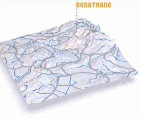 Places with similar names to Ben Atmane, Morocco ::
// Ban Ta Man (TH)
// Ban Tam Nai (TH)
// Ban Tamuan (TH)
// Ban Ta Mun (TH)
// Ban Ta Mun (TH)
// Ban Tom Nua (TH)
// Ban Tom Nua (TH)
// Ban Tum Nua (TH)
// Bendimón (ES)
// Band Amān (IR)
Disclaimer :: Information on this page comes without warranty of any kind |
||
|
Where is Ben Atmane? Elevation and coordinates ::
Latitude (lat): 33°56'0"N Longitude (lon): 4°8'0"W
Elevation (approx.): 1214m (map arrows pan, magnifying glasses zoom) |
||
|
Visiting Ben Atmane? Hotel/Accommodation ::
Book a hotel in Ben Atmane Travel Guide ::
Buy a travel guide for Morocco rental cars ::
car rental offers GPS waypoint ::
download a GPX waypoint (PoI) of Ben Atmane for your GPS receiver
|
||