|
search place name
|
||
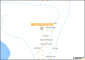
Beni Semguine (Ouarzazate, Morocco)Beni Semguine is a town in the Ouarzazate region of Morocco. An overview map of the region around Beni Semguine is displayed below.
regional and 3d topo map of Beni Semguine, Morocco ::
Beni Semguine airports ::
The nearest airport is OZZ - Ouarzazate, located 161.1 km north west of Beni Semguine.
Other airports nearby include ERH - Er-rachidia Moulay Ali Cherif (236.5 km north east), Nearby towns ::
Iggsouarene (1.9km south) //
Najia (1.6km east) //
Zaouia Idida (3.2km east) //
Zaouia Moulay Cherif (3.2km east) //
Tachat (3.2km east) //
Ksir Ignaouene (3.7km north east) //
Nesrat (4.0km south east) //
Knazda (4.0km south east) //
Inissi (5.8km south) //
Douafil (5.8km south) //
Ksebt er Remla (5.8km south) //
Zaouia Sidi Yahya (6.4km south east) //
Tahramt (7.4km south) //
Ksar Jdid (7.4km south) //
Beni Hayyoum (7.6km south) //
[all distances 'as the bird flies' and approximate]  Places with similar names to Beni Semguine, Morocco :: Disclaimer :: Information on this page comes without warranty of any kind |
||
|
Where is Beni Semguine? Elevation and coordinates ::
Latitude (lat): 30°4'0"N Longitude (lon): 5°34'0"W
Elevation (approx.): 641m (map arrows pan, magnifying glasses zoom) |
||
|
Visiting Beni Semguine? Hotel/Accommodation ::
Book a hotel in Beni Semguine Travel Guide ::
Buy a travel guide for Morocco rental cars ::
car rental offers GPS waypoint ::
download a GPX waypoint (PoI) of Beni Semguine for your GPS receiver
|
||