|
search place name
|
||
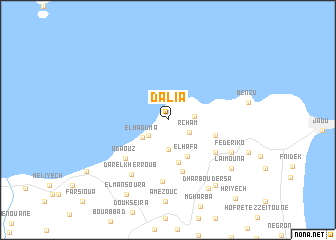
Dalia (Tétouan, Morocco)Dalia is a town in the Tétouan region of Morocco. An overview map of the region around Dalia is displayed below.
regional and 3d topo map of Dalia, Morocco ::
Dalia airports ::
The nearest airport is GIB - Gibraltar, located 30.4 km north east of Dalia.
Other airports nearby include TTU - Tetouan Saniat Rmel (36.8 km south east), TNG - Tanger Ibn Batouta (43.8 km south west), XRY - Jerez (107.3 km north west), AGP - Malaga (123.3 km north east), Nearby towns ::
El Haouma (2.4km south west) //
Rcham (2.4km south east) //
Taoutiet el Bioute (2.4km east) //
Bou Reïhal (3.3km south) //
El Haouma (3.0km south west) //
El Hafa (4.5km south east) //
Mrah ed Debbane (4.9km south) //
El Horra (4.6km east) //
El Mtabakh (5.9km south) //
El Bioutz (5.6km south east) //
Agaouz (5.8km south west) //
Anasser (6.9km south) //
Dar el Kherroub (6.9km south west) //
Federiko (6.8km south east) //
Dhar Boudersa (8.5km south east) //
Laimouna (7.9km south east) //
Dchar Loudana (8.5km south east) //
El Mansoura (9.1km south west) //
Hriyech (10.7km south east) //
[all distances 'as the bird flies' and approximate] 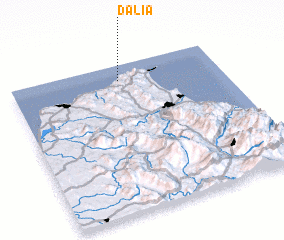 Places with similar names to Dalia, Morocco ::
Disclaimer :: Information on this page comes without warranty of any kind |
||
|
Where is Dalia? Elevation and coordinates ::
Latitude (lat): 35°53'56"N Longitude (lon): 5°28'51"W
Elevation (approx.): 198m (map arrows pan, magnifying glasses zoom) |
||
|
Visiting Dalia? Hotel/Accommodation ::
Book a hotel in Dalia Travel Guide ::
Buy a travel guide for Morocco rental cars ::
car rental offers GPS waypoint ::
download a GPX waypoint (PoI) of Dalia for your GPS receiver
|
||