|
search place name
|
||
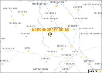
Dar Ahmar Ben Abida (Safi, Morocco)Dar Ahmar Ben Abida is a town in the Safi region of Morocco. An overview map of the region around Dar Ahmar Ben Abida is displayed below.
regional and 3d topo map of Dar Ahmar Ben Abida, Morocco ::
Dar Ahmar Ben Abida airports ::
The nearest airport is RAK - Marrakech Menara, located 74.1 km east of Dar Ahmar Ben Abida.
Other airports nearby include AGA - Agadir Inezgane (153.7 km south west), OZZ - Ouarzazate (196.5 km east), CMN - Casablanca Mohammed V Intl (225.8 km north east), Nearby towns ::
El Krinate (2.7km north east) //
Dar Oulad Ahmad (5.6km north) //
Zaouïa Oulad Rahou (5.7km north east) //
Zouinate (5.7km south east) //
Mannsour (6.7km south) //
Sidi Sadoum (7.4km north) //
Ladilate (6.8km north west) //
Zaouia Oulad Mokaddem (7.3km south east) //
El Mouinèt (7.6km east) //
Chichaoua (9.4km south east) //
Amdel (9.0km south west) //
Oulad el Khedam (10.3km north east) //
[all distances 'as the bird flies' and approximate] 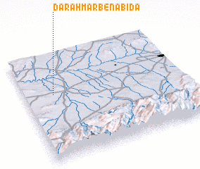 Places with similar names to Dar Ahmar Ben Abida, Morocco :: Disclaimer :: Information on this page comes without warranty of any kind |
||
|
Where is Dar Ahmar Ben Abida? Elevation and coordinates ::
Latitude (lat): 31°37'0"N Longitude (lon): 8°49'0"W
Elevation (approx.): 302m (map arrows pan, magnifying glasses zoom) |
||
|
Visiting Dar Ahmar Ben Abida? Hotel/Accommodation ::
Book a hotel in Dar Ahmar Ben Abida Travel Guide ::
Buy a travel guide for Morocco rental cars ::
car rental offers GPS waypoint ::
download a GPX waypoint (PoI) of Dar Ahmar Ben Abida for your GPS receiver
|
||