|
search place name
|
||
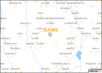
El Mjed (Marrakech, Morocco)El Mjed is a town in the Marrakech region of Morocco. An overview map of the region around El Mjed is displayed below.
regional and 3d topo map of El Mjed, Morocco ::
El Mjed airports ::
The nearest airport is RAK - Marrakech Menara, located 29.6 km north east of El Mjed.
Other airports nearby include OZZ - Ouarzazate (136.2 km east), AGA - Agadir Inezgane (168.9 km south west), CMN - Casablanca Mohammed V Intl (226.4 km north), Nearby towns ::
El Arissa (2.4km south east) //
El Karia (3.7km north) //
Mkhalif (3.7km north west) //
El Gaïda (4.9km south west) //
Mohammed Ben Abdarrahmane (5.6km north) //
Frizem (4.7km west) //
El Jorf (5.1km west) //
Douar Sidi Arich (6.3km west) //
Souk Sou (6.6km east) //
Taïzelt (7.3km south east) //
El Moukhtar (7.3km north east) //
Goujgal (7.3km south west) //
Nzala (8.1km north west) //
Ouaouizelt (8.4km south east) //
Wawizelt (8.4km south east) //
Makhfamane (8.8km south east) //
[all distances 'as the bird flies' and approximate] 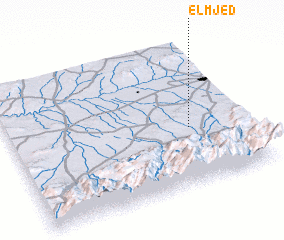 Places with similar names to El Mjed, Morocco ::
// El Moujoud (MA)
Disclaimer :: Information on this page comes without warranty of any kind |
||
|
Where is El Mjed? Elevation and coordinates ::
Latitude (lat): 31°24'0"N Longitude (lon): 8°14'0"W
Elevation (approx.): 693m (map arrows pan, magnifying glasses zoom) |
||
|
Visiting El Mjed? Hotel/Accommodation ::
Book a hotel in El Mjed Travel Guide ::
Buy a travel guide for Morocco rental cars ::
car rental offers GPS waypoint ::
download a GPX waypoint (PoI) of El Mjed for your GPS receiver
|
||