|
search place name
|
||
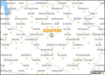
Igoufrar (Tiznit, Morocco)Igoufrar is a town in the Tiznit region of Morocco. An overview map of the region around Igoufrar is displayed below.
regional and 3d topo map of Igoufrar, Morocco ::
Igoufrar airports ::
The nearest airport is AGA - Agadir Inezgane, located 78.7 km north of Igoufrar.
Other airports nearby include TTA - Tan Tan Plage Blanche (227.0 km south west), RAK - Marrakech Menara (244.4 km north east), TIN - Tindouf (248.5 km south east), Nearby towns ::
Tizi Iferdane (1.6km west) //
Aït Amrane (2.5km north west) //
Assdrem (2.5km north east) //
Andserfa (3.7km south) //
Anla (3.7km north) //
Amechtrik (4.0km north west) //
Anzt (4.0km north east) //
Agounsi (4.9km south east) //
Bel Moussa (4.8km west) //
Aït el Mouzazi (4.8km west) //
Aït Aïs (4.8km east) //
Tiroula (5.6km south) //
Aït Hassane (5.8km south) //
Ouchene (5.8km south) //
Ferinid (5.2km west) //
Agsime (5.2km east) //
Agrougoum (5.8km north) //
Imi nʼ Tagant (5.8km south) //
Aït Zial (5.2km east) //
Anezi (6.1km south west) //
Agourdouar (6.4km north west) //
Iguiferd (6.1km north east) //
Igoujjimene (7.4km south) //
Aït Ou Bouzid (6.7km west) //
Aït Dameuse (7.6km south) //
Agourd Ou Mzoul (7.6km north) //
Aït Messaoud (6.7km east) //
Aït Talb (7.4km north west) //
Tourouma (7.4km north west) //
[all distances 'as the bird flies' and approximate] 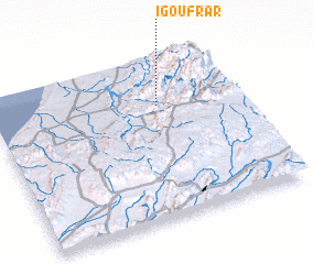 Places with similar names to Igoufrar, Morocco :: Disclaimer :: Information on this page comes without warranty of any kind |
||
|
Where is Igoufrar? Elevation and coordinates ::
Latitude (lat): 29°42'0"N Longitude (lon): 9°19'0"W
Elevation (approx.): 693m (map arrows pan, magnifying glasses zoom) |
||
|
Visiting Igoufrar? Hotel/Accommodation ::
Book a hotel in Igoufrar Travel Guide ::
Buy a travel guide for Morocco rental cars ::
car rental offers GPS waypoint ::
download a GPX waypoint (PoI) of Igoufrar for your GPS receiver
|
||