|
search place name
|
||
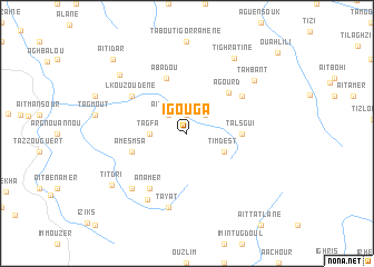
Igouga (Marrakech, Morocco)Igouga is a town in the Marrakech region of Morocco. An overview map of the region around Igouga is displayed below.
regional and 3d topo map of Igouga, Morocco ::
Igouga airports ::
The nearest airport is OZZ - Ouarzazate, located 63.0 km south east of Igouga.
Other airports nearby include RAK - Marrakech Menara (76.1 km west), CMN - Casablanca Mohammed V Intl (218.5 km north), Nearby towns ::
Azarif (1.9km north) //
Talzgui (2.2km north) //
Aït Aïssa (2.4km north west) //
Tarhia Aït Alou (2.4km north east) //
Tagfa (3.2km west) //
Timdest (3.7km south east) //
Talsgui (4.7km east) //
Amesmsa (5.1km west) //
Agourd (5.4km north east) //
Abadou (5.8km north) //
Lkouzoudene (6.0km north west) //
Aguensou (6.0km north east) //
Anamer (6.4km south west) //
Tafraout (6.4km south west) //
Anammer (7.6km south) //
Tayat (7.6km south) //
Titoula (7.5km south west) //
Tamezmout (7.3km south west) //
Tahbant (7.9km north east) //
Tighratine (8.6km north east) //
Ikouzoudane (8.2km north west) //
Titdri (8.3km south west) //
Aït Idar (9.7km north west) //
[all distances 'as the bird flies' and approximate] 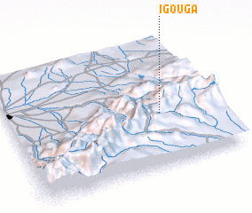 Places with similar names to Igouga, Morocco ::
Disclaimer :: Information on this page comes without warranty of any kind |
||
|
Where is Igouga? Elevation and coordinates ::
Latitude (lat): 31°25'0"N Longitude (lon): 7°16'0"W
Elevation (approx.): 2575m (map arrows pan, magnifying glasses zoom) |
||
|
Visiting Igouga? Hotel/Accommodation ::
Book a hotel in Igouga Travel Guide ::
Buy a travel guide for Morocco rental cars ::
car rental offers GPS waypoint ::
download a GPX waypoint (PoI) of Igouga for your GPS receiver
|
||