|
search place name
|
||
Iguerguer (Taroudannt, Morocco)Iguerguer is a town in the Taroudannt region of Morocco. An overview map of the region around Iguerguer is displayed below.
regional and 3d topo map of Iguerguer, Morocco ::

Iguerguer airports ::
The nearest airport is AGA - Agadir Inezgane, located 31.0 km south west of Iguerguer.
Other airports nearby include RAK - Marrakech Menara (167.5 km north east), Nearby towns ::
Iguerguer (0.2km south east) //
Dkiila (1.9km north east) //
Igber Ouzedder (2.2km south) //
Tasdert (2.6km south east) //
Tasdert (2.6km south east) //
Agafal (4.0km south) //
Aït Lâsri (4.1km north east) //
Mtrhoulest (4.2km north west) //
Guertsdar (4.6km south) //
Bou Zemmour (4.7km north) //
Guertsdar (4.8km south) //
Ameskroud (4.3km west) //
Ameskroud (4.4km west) //
Sidi Mohand Ou Brahim (4.8km east) //
Bouria (4.9km east) //
Tinfoul (5.0km west) //
Tarharast (5.5km north west) //
Bou el Borj (6.7km south) //
Aït Ou Azad (6.0km west) //
Oued Issene (6.8km south) //
Tiziouint (6.4km east) //
Aït Ou Azad (6.6km west) //
Aït Hassassa (7.3km south east) //
Mzerguia (7.3km south east) //
Tagadirt (8.2km north) //
Ikis (8.3km north) //
Sidi Bou Shab (9.1km south) //
Riaïna (9.7km south east) //
Aït ou Alach (9.9km north west) //
[all distances 'as the bird flies' and approximate] 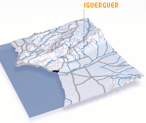
Disclaimer :: Information on this page comes without warranty of any kind |
||
|
Where is Iguerguer? Elevation and coordinates ::
Latitude (lat): 30°32'35"N Longitude (lon): 9°16'58"W
Elevation (approx.): 192m (map arrows pan, magnifying glasses zoom) |
||
|
Visiting Iguerguer? Hotel/Accommodation ::
Book a hotel in Iguerguer Travel Guide ::
Buy a travel guide for Morocco rental cars ::
car rental offers GPS waypoint ::
download a GPX waypoint (PoI) of Iguerguer for your GPS receiver
|
||