|
search place name
|
||
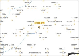
Irherm (Marrakech, Morocco)Irherm is a town in the Marrakech region of Morocco. An overview map of the region around Irherm is displayed below.
regional and 3d topo map of Irherm, Morocco ::
Irherm airports ::
The nearest airport is RAK - Marrakech Menara, located 78.7 km north of Irherm.
Other airports nearby include OZZ - Ouarzazate (115.5 km east), AGA - Agadir Inezgane (148.6 km west), Nearby towns ::
Imi Ou Tislit (0.0km north) //
Tazoudat (1.6km east) //
Targa (1.6km east) //
Afourirh (2.4km south west) //
Agoudim (3.7km south) //
Aït Sekri (3.2km west) //
Agadir nʼ Afra (3.2km east) //
Tamdrhoust (3.7km north west) //
Tazoudat nʼOufella (3.7km south east) //
Mejjou (4.9km north east) //
Takoucht (5.8km south) //
Tamselloumt (5.1km west) //
Sidi Moussa (6.0km south west) //
Tagordnit (6.4km west) //
Taguedid Tahtani (6.6km east) //
Tijricht (7.6km north) //
Tanefit (7.6km north) //
Tisgui (7.4km north east) //
Taguedid Foukani (7.4km north east) //
Tazougart (8.1km north east) //
[all distances 'as the bird flies' and approximate]  Places with similar names to Irherm, Morocco ::
Disclaimer :: Information on this page comes without warranty of any kind |
||
|
Where is Irherm? Elevation and coordinates ::
Latitude (lat): 30°54'0"N Longitude (lon): 8°7'0"W
Elevation (approx.): 1499m (map arrows pan, magnifying glasses zoom) |
||
|
Visiting Irherm? Hotel/Accommodation ::
Book a hotel in Irherm Travel Guide ::
Buy a travel guide for Morocco rental cars ::
car rental offers GPS waypoint ::
download a GPX waypoint (PoI) of Irherm for your GPS receiver
|
||