|
search place name
|
||
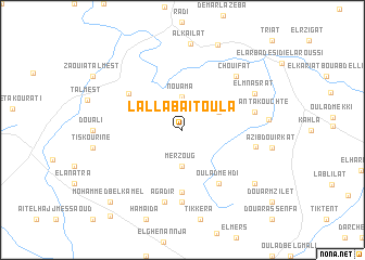
Lalla Baïtoula (Essaouira, Morocco)Lalla Baïtoula is a town in the Essaouira region of Morocco. An overview map of the region around Lalla Baïtoula is displayed below.
regional and 3d topo map of Lalla Baïtoula, Morocco ::
Lalla Baïtoula airports ::
The nearest airport is RAK - Marrakech Menara, located 116.7 km east of Lalla Baïtoula.
Other airports nearby include AGA - Agadir Inezgane (158.0 km south), CMN - Casablanca Mohammed V Intl (234.9 km north east), Nearby towns ::
Nouama (3.4km north) //
Merzoug (3.7km south) //
Oulad Abdallah el Bouiri (3.7km north east) //
Douar Sidi Bou Alam (6.5km south) //
Oulad Mehdi (6.4km south east) //
Ouled Fhrira (6.0km north west) //
Aït el Ayachi (7.4km south) //
Agadir (7.6km south) //
Afella nʼTakouchte (6.6km east) //
Jouadra (6.6km east) //
Chouifat (7.3km north east) //
El Mnasrat (7.3km north east) //
Zouitinat (7.6km east) //
Al Kailat (8.9km north) //
Rahla (8.4km south east) //
El Mouilhat (9.3km north) //
Mohammed Bel Kamel (9.7km south west) //
El Arba des Naïrat (10.9km south west) //
[all distances 'as the bird flies' and approximate]  Places with similar names to Lalla Baïtoula, Morocco ::
// Lala Beïd Oula (MA)
Disclaimer :: Information on this page comes without warranty of any kind |
||
|
Where is Lalla Baïtoula? Elevation and coordinates ::
Latitude (lat): 31°47'0"N Longitude (lon): 9°15'0"W
Elevation (approx.): 387m (map arrows pan, magnifying glasses zoom) |
||
|
Visiting Lalla Baïtoula? Hotel/Accommodation ::
Book a hotel in Lalla Baïtoula Travel Guide ::
Buy a travel guide for Morocco rental cars ::
car rental offers GPS waypoint ::
download a GPX waypoint (PoI) of Lalla Baïtoula for your GPS receiver
|
||